This is the other Red Paint track that starts in the same place from the Organ Pipes Track.
As you can see, it was a foggy day, but no rain and not too cold. There is lots of boulder climbing, forget hopping. Some of these were really tough to get up and people had to give each other a hand.
As I said, it was foggy, but everything nearby was clear so no problem finding our way. Looking in the direction of Hobart was another matter as it was just a wall of white. The only time it broke was during morning tea when suddenly a hole appeared just like a small window and I could see some of Hobart quite clearly as if it was in a picture frame. Unfortunately, by the time I got my camera out, it filled in again.
The climb goes up through a space in the Organ Pipes and comes out just below the commercial T.V. tower. From there we walked down the road and picked up the track to the Luckmans Hut about 200 metres down where we had lunch.
After lunch we started down to pick up the Panorama Track which cuts off Big Bend and comes out on the road. We planned to walk back to the Chalet on the shoulder. I was last out as usual and suddenly I heard a CRACK! like a rifle shot.
One of the walkers had fallen and hit their head on a large rock. They didn't loose consciousness, but were dazed. We decided that I would continue on to pick up the walking track, make my way to the road and pickup my car to come back. In the meantime the others would take the patient back to Luckmans Hut. Which we did.
When I got back to the top with the car, Gordon was waiting for me to say they had called an ambulance as they were worried about a head injury. Meanwhile the fog was really getting thick.
When the ambos arrived, one was in short sleeves and the other had a sweater on, so Gordon had a spare coat he loaned the first one. We walked back to the Hut where they examined the patient and determined it was ok to walk back up to the road, while one of them supported their head & neck and others of us made sure no one fell, as it was walking over rocks and clumps of vegetation.
Reaching the top, it was nearly a white out while the ambulance drove very slowly down. I took everyone down to their cars and we called it a day.
The injured walker had sustained a crack in the back of their skull and was not walking for a number of weeks, but is now happily back with their own group nearer to home.
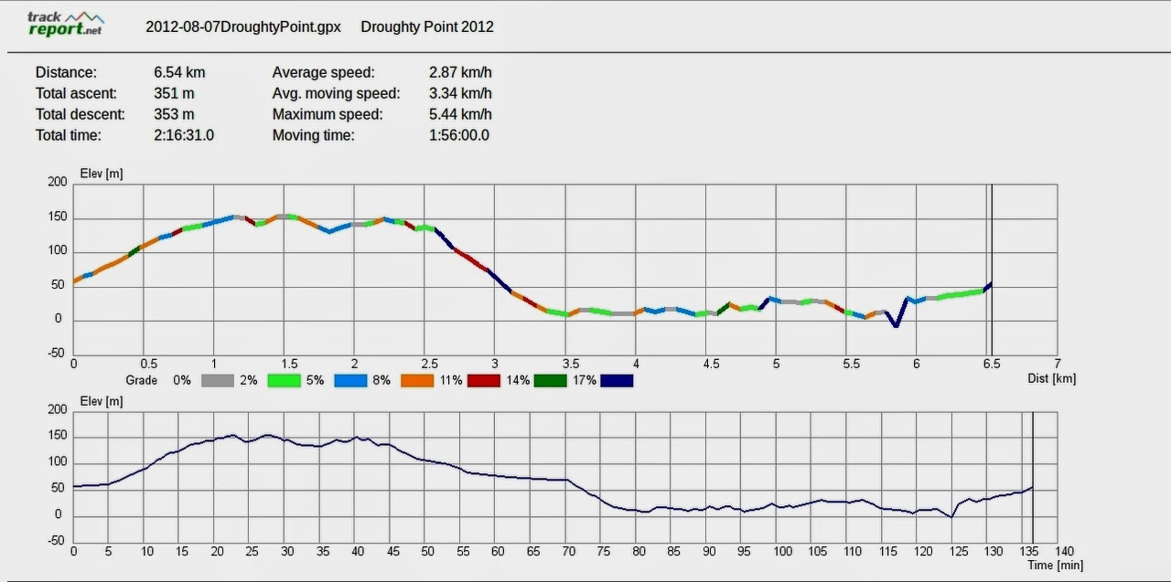
I think there were 6 of us and we walked 4.5km in 3:24 hours.
Click here to download GPX file
 |
| Ready to start |
 |
| This is the easy part |
 |
| Addie still smiling, John being photographed while photographing. Peggy in the middle |
 |
| Last we see of Hobart |
 |
| Up and into the fog |
 |
| Still smiling |
 |
| Feral goat hung up on a bush. I guess it slipped and wonder how many live up there. |
 |
| I think this was Morning tea |
 |
| Reached the road, walking down to track to Luckmans Hut |
 |
| Track to hut |
 |
| Luckmans Hut |
 |
| Picking up car to drive back up |