Tuesday 25 March 2014

Waterworks to Fern Tree

Today's walk was led by Gordon. Driving up to Kingston to our meeting place, I had my doubts about the weather, as I had the wipers on most of the way. However, it wasn't raining when we reached the Waterworks, and indeed was sunny by lunch time.

Parking outside the gates, we walked in and across the top of the dam. I think Gordon might have mentioned a little hill at the start. It is a little hill, but fairly steep. The indication of this are the finger marks made by the people going ahead of you.

At the top we reached the Huon Road and walked a short distance up it before crossing and walking on a pleasant track in the bush. The bush was looking at it's best as it was still wet from the previous rain. After a while we came back to the Huon Rd., walked up to a street marked 'Fingerpost Track' and turned off.

You won't be surprised when I tell you it is a fairly steep climb past some houses to meet the tracks in the bush. Gordon offered the incentive of morning tea at the top, by the water tank.

After the break, we walked back along the Fingerpost track and followed it around the side of the mountain, passing through Fern Glade, viewing Silver Falls, and back down through Fern Tree Bower to the settlement of Fern Tree.

Crossing the road, we avoided the pub and took the Pipeline track down past the aqueduct and back to the upper reservoir where we had lunch in the sun.

A walk we've done before, and a good one thanks to Gordon.


Car park


Looking across the reservoir

Through bush


Looking down Fingerpost Track to start


Looks like a warm home

Morning tea


Along the Fingerpost track


Man Ferns

Top of Silver Falls


Bottom of Silver Falls

Fern Glade


Aqueduct

Crossing at Fern Tree


Google Earth

Map
Elevation profile


 We had 14 walkers, and traveled 12.2km in 3.42 hours.

Click here to download GPX file


MAKE SURE YOU READ THE BLOG
CALLED SAFETY!!!


Thursday 20 March 2014

Risdon Vale

This week was a new walk by Bob in the hills behind Risdon Vale, and it was a very good walk.

Mostly up hill, but fairly gentle, it covered a variety of interests. Botany, and several 'ologies' such as geology, industrial archeology and criminology. Maybe a new one you could call rubbishology.

Starting out in the car park in the throbbing centre of Risdon Vale, a track led through the recreation area back to the hills via a fire trail, then a foot track going up. Very dry bush and good views when you got a bit higher.


Ready to leave, hoping the cars will be there when we return

Across the recreation ground
View over Risdon Vale


Starting up

Bob said we would have morning tea near a cave he had discovered during his first exploration of the area, so we turned off onto a barely discernible track and came up under some stone cliffs. Unfortunately, no cave was in sight, and this led to may jokes about a sequel to Nan Chauncy's book "They Found a Cave" e.g., "They Didn't Find a Cave" and such like.

Bob took it well (he's used to it), but decided to go exploring while we rested to see if he could find it. He came back looking pleased with himself as the cave was just a little way around the cliff. For those that took the time to have a look, it wasn't a large cave but quite a nice one, so well worth the effort.

Bob about to look pleased with himself

Bob's cave

Back to my roots - by Carol


Cave denizens

Heading back down - by Carol


Walking back to the main track we headed up once again, passing with heads down the No Trespassing sign posted high on a tree and wound our way up to a large rock shelf. I've found a reference to this property on the Internet. It's called Basin Downs and is 217 acres and sold for $129,000. Not bad.

Here's a copy of some of the relevant info.

"The property occupies a key strategic position in the Meehan Range, which has been identified by the TLC as one of six 'focal landscapes' for biodiversity conservation around Tasmania.  It bisects two areas of the Meehan Range Nature Recreation Area and it's protection helps secure the viability of the broader landscape.  It contains two threatened forest communities (vulnerable dry Blue Gum forest and rare Risdon Peppermint forest) and habitat for several threatened species, including the endangered Swift Parrot, Masked Owl and Wedge-tailed Eagle. The topography and geology of the block (including spectacular cliffs and caves) provides great structural diversity which supports a high overall diversity of native flora and fauna."

Unfortunately, no animals appeared, maybe next time.

We continued up to a large, fairly flat area dropping down over stone cliffs. The first stop was at a spot with a number of shallow depressions in  the rock and I suspect the reason it's called Basin Downs. The next stop was again on top of taller cliffs. We then walked down and around to revel the good sized cave we'd been standing on.


Stone Basins

On top of next cave

Basin with lid

Bob and larger cave


After that we found a convenient log for lunch before walking, sliding, barely controlled falling, down a long, steep, loose stoned, slippery slope to Risdon Vale Creek  and back to the cars.

Lunch on a log
Slippery Slope


I refrained from taking photos of the several burnt out cars, but in hindsight I should have treated them like installation art. You could mine that area for all the molten aluminium from burnt out vehicles.

Thanks to Carol for her photos.


Elevation profile

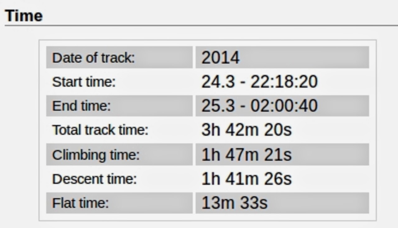
Notice the time on the flat


We had 12 walkers and covered 9.35km in 3.37 hours.

Click here to download GPX file

Thursday 13 March 2014

Burwood Rd. to Howden & Return.

This week's walk took place on what became a very warm day - 32C when I got back to my car.

Bob was our leader, and took us on a merry chase around and about the Peter Merrill Reserve, to kill time before Morning Tea. This was taken at the Pony Club and nearly turned into a disaster!

Usually, when we stop there on their covered deck, there's a large leather couch for the elite to sit on. Today, that appeared to be missing, and I've never see someone so shaken. It was as if their world had turned upside down. However, it turned out it just had been moved AND had been joined by another couch. All was right with the world again.

After tea we walked over jumps, climbed under fences and walked down roads surrounded by all kinds of dangerous animals. Two guard Labradors at one property threatened to lick us to death, followed by a group of attack Lamas or Alpacas - not sure which.

We walked around the foreshore as the tide was out, and this was more pleasant then walking along the road. The group then took a track along a gully and around the back of some of Howden to return to the foreshore again, only to cross some mudflats at the beautifully named Stinkpot Bay. Then back to the Pony Club couches for lunch, followed by a direct route back to the cars.

Off into the bush

Gordon about to disappear in the vegetation

I tried to get a better action photo of 'Bwana' Bob clearing the trail with a large stick

Pony Club couches.

Morning tea

On the pavement

Attack Lamas/Alpacas

Howden foreshore

View across to Margate

Cave on other side of gully

Peter at back, David in red, Peggy & Bob

More foreshore on way back

Peggy decided to limbo under fallen tree

Mudflats at Stinkpot Bay


Track report


A quick word about distance, I carry a GPS tracker as do 2 other people. Mine registered 14.3km, David was, I think, 13.76km and Peggy had 13.26km or there abouts. Either GPS isn't that accurate or someone has been slacking. Take whatever figure you feel comfortable with.

We had 11 walkers for most of the way, 3 had to leave for other duties/classes, and we took just over 4 hours.

Click here to download GPX file