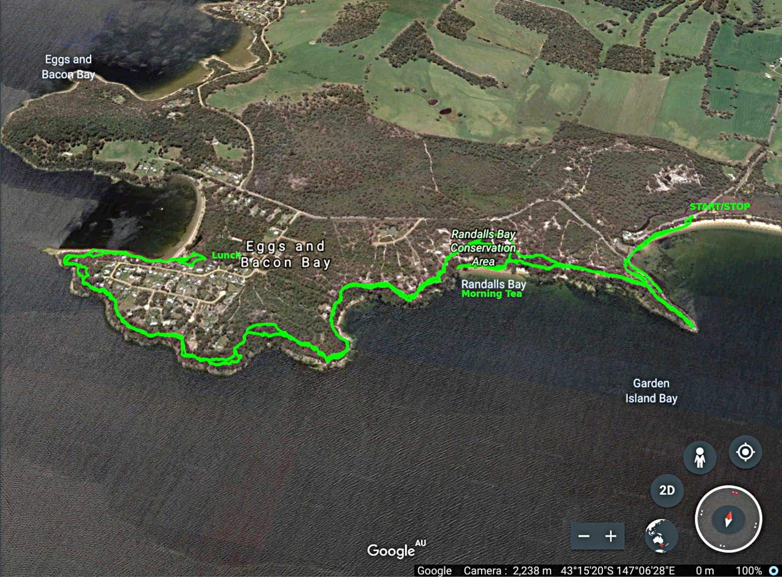
Today Bob's taking us on a new walk at Randalls Bay in the south of the state. This is about 45 minutes drive from Kingston.
Meeting outside my place at Woodbridge, Bob takes us over Woodbridge Hill so the travel time might be a little out, but this does create a loop as we take the direct route back after the walk.
Weather at Woodbridge was fine, but overlooking the Huon from the top of Woodbridge Hill you can see scattered showers and cloud.
We arrive at Randalls Bay and get ready to set off.
 |
| Right spot |
 |
| Ready for the off |
Once on the beach, if you look to the left, there is a fairly new walk for another day. That is on Echo Sugarloaf by the Friends of Randalls Bay Coastcare Group, and is something to look forward to. We're heading in the other direction and make our way down the beach.
 |
| Echo Sugarloaf. Site of a future walk |
 |
| Heading away from the above walk |
 |
| Lying alone I thought I should take its photo. Only a little farther there are dozens of them |
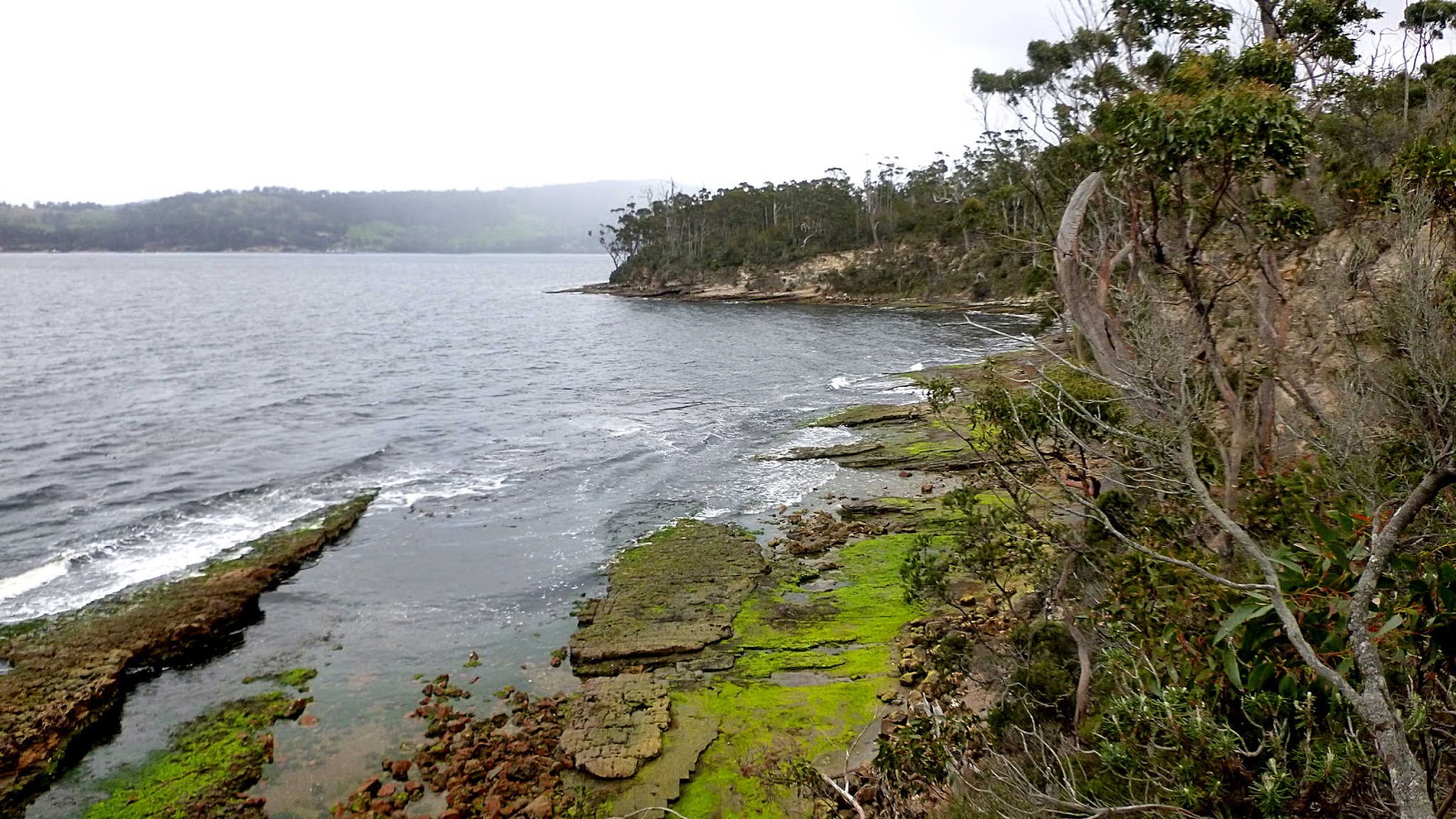
There is a raised section running just above the water. Sections are missing, but for the moment it appears o.k. for walking.
 |
| Randalls Bay |
 |
| The track |
 |
| A local |
 |
| Cliff rising up from our track |
It's been a while since Bob walked here and it looks like things have changed. Leaving us in the flat ground, Bob goes exploring.
Unfortunately, there is not an easy way forward from here, so we make the short trek back to the start. Here we find a nicely constructed set of steps that take us to the top of the cliff and onto a nice track.
 |
| Flowering tree on the way |
 |
| Top of steps with the beach below |
 |
| The track |
The track leads out to a point overlooking Randalls Bay and Garden Island Bay farther out.
 |
| Garden Island in the distance |
 |
| Looking down the Huon River |
 |
| Don't worry Ron, things will always get better |
We make our way back to the main track and turn left onto a well marked track.
On the way, I find a bit of colour beside the track. I've seen these on some of our walks beside the water at Coningham.
The track widens now. Over the years there has been considerable gravel mining in this area and there is an active quarry on the back of Echo Sugarloaf, off the Channel Highway.
Many years ago Randalls Bay gravel was recommended to me as being suitable for a concrete mix. It contained sand and quartz pebbles and only required cement and water in the right proportions.
Randalls Bay gravel was used in the construction of the old floating bridge that spanned the River Derwent at Hobart before the present Tasman Bridge.
 |
| Easy walking |
 |
| Heading down to Mickeys Beach for Morning Tea |
 |
| Morning Tea |
 |
| Still weather around, but we stay dry |
 |
| I thought those dark vertical lines were roots, until I got closer |
 |
| They are actually veins of a mineral that is harder than the sandstone. This produces a 3D blade type of effect where it's filled narrow cracks |
Back up to the track to continue on. Quarrying has occurred in much of this area.
 |
| Left high and dry by past quarry operations |
 |
| Lots of lichen in some areas |
We make our way around Cray Point, passing gardens of people who live here full time in some cases.
 |
| Bush garden. We're on public land |
 |
| Surveyors Bay in the distance |
 |
| Eggs and Bacon Bay up ahead |
 |
| Multicoloured shore |
 |
| Looks like a large pipe ran down here in the past |
 |
| Eggs and Bacon Bay |
|
Named after wild flowers that are plentiful here, Eggs and Bacon Bay have had that name for 140 years.
Back in 2016 there was a flurry of news that went global. PETA - People for the Ethical Treatment of Animals, wanted to change the name to Apple and Cherry Bay.
That stirred things up, I can tell you.
 |
| Eggs and Bacon flowers. Member of the pea family |
It took sometime for the world to return to normal. Oh, the name didn't change.
Back to our walk, we descend to the rocky foreshore to make our way to the beach and lunch.
 |
| The steps down have seen better days |
We reach the beach which has a large public area behind with toilets and a picnic table.
 |
| Lunch with shacks behind |
I go for a wander and spot a couple of interesting signs.
I hope the above sign is still true as there were several new survey stakes and flags not far from it.
The other thing I had a look at was the sewage processing plant.
 |
| Why did I include this? I hear you ask |
Well, it had an interesting sign.
Really? A warning about confined space? I would have thought that the chance of contracting some sort of dreaded lurgy from raw sewage or falling into a tank that has rotating blades inside that could turn you into unsavoury mince before you could shout "Holy S...!!" would be more of a worry than a bout of claustrophobia.
But that's just me.
Back to the walk.
Lunch finished, Bob has had a look around for another exit with no luck, so we retrace our steps along the foreshore. We do take a different set of steps up to the track though, bypassing those dodgey metal stairs.
 |
| Eggs and Bacon Bay beach |
 |
| Looking towards Police Point and Mount Esperance |
 |
| As you can tell from the water, the sun has come out |
On the way back, Bob does his best to vary our track.
 |
| Someone's insect hunting ground |
 |
| Mickeys Beach below |
 |
| About to descend the steps onto Randalls Bay beach |
 |
| I think that's Mount Cygnet in the distance |
We had 12 walkers and covered 8.79kms in 3:51hrs. Very interesting area and actually good weather. Thanks to Bob for taking us there.
I've made an animated track just for general interest.
Click here to view animated track
Click here to download GPX file