Unfortunately I was unable to attend this walk. Bob rang me and said they had 14 walkers turn up, however when they reached the start of the walk, there were signs closing the track due to fuel reduction burns.
Bob saved the day and took the group to another track some distance away. This took them to the top of the hill near the mobile phone tower.
Everyone enjoyed the day, thanks to Bob.
Jack
Anyone interested can CLICK HERE to see what the original walk would have covered. This was back in 2016.
Thursday, 29 March 2018
Friday, 23 March 2018
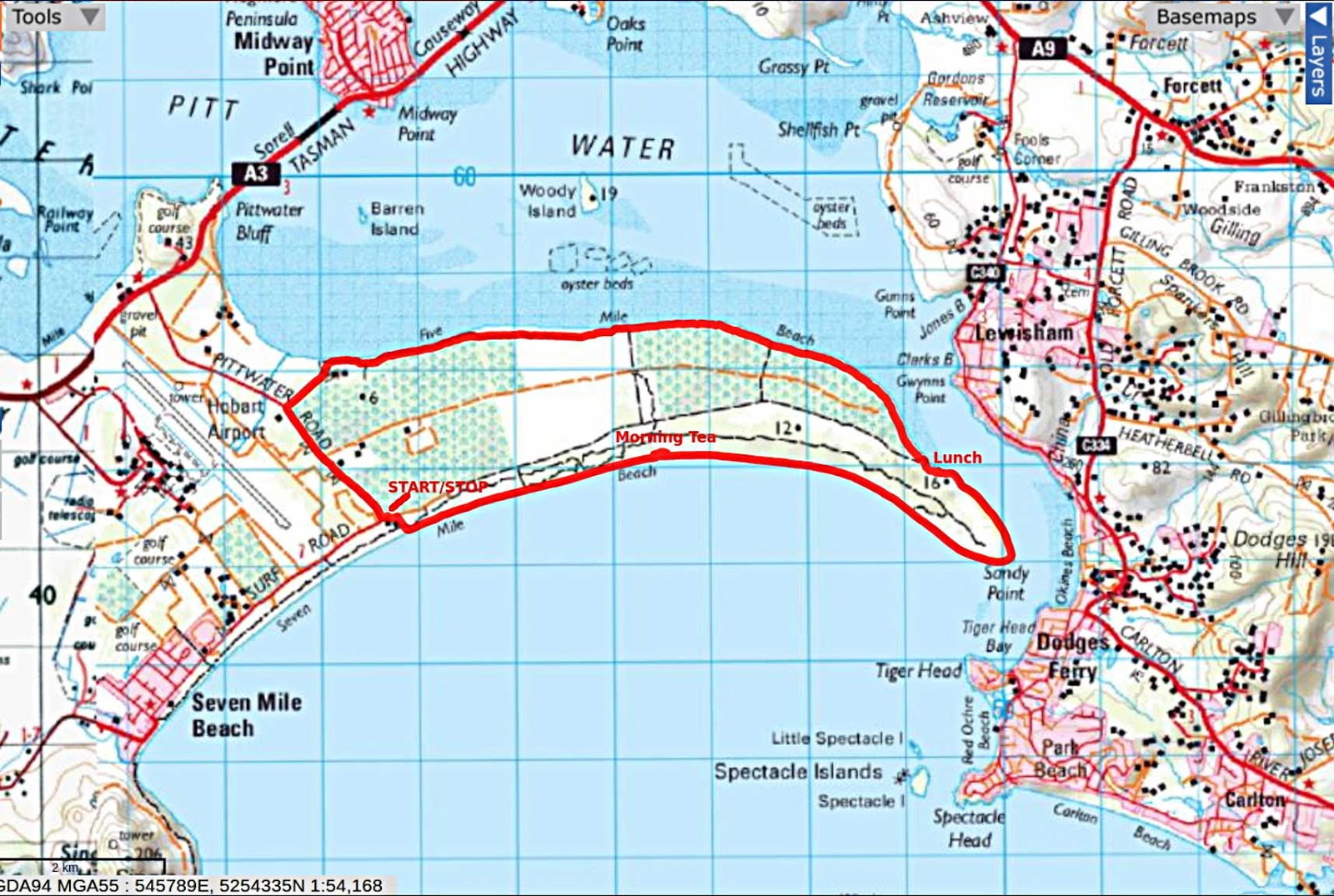
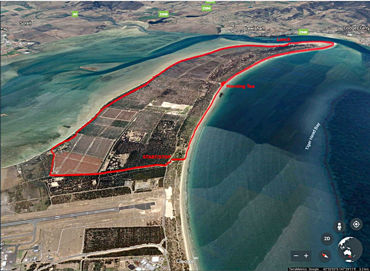
Seven & Five Mile Beach Circuit 2018
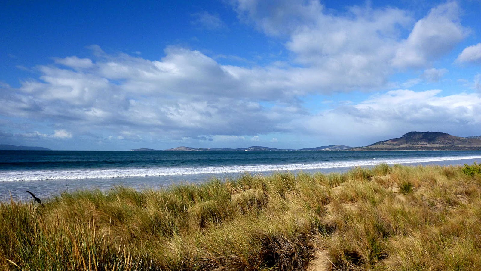
Today we're walking the Seven Mile Beach-Five Mile Beach circuit. Parking next to the Ranger station off Surf Road, we gear up and go, heading for the beach.
The weather isn't too bad at the moment, but there is a constant tail wind blowing.
Another packed Tasmanian beach.
There are views all around, soon we come to a spot where we take Morning Tea, climbing up behind the dune out of the wind.


I return to the beach, walking back to join the others. A little fine rain appears, but not enough to encourage me to don waterproofs.
Not much interesting debris on this beach (except for plastic) which one of our walkers is picking up.

A few interesting shells appear and lots of little shells that Peter thinks is oyster spat and looking on line, I think he's right.


It doesn't appear that it will affect us as it's heading north. Besides, there's a rainbow to the left.
It's more pleasant as we've left the wind behind. As the beach narrows, we move inshore to find a place for lunch.

Lunch finished, Bob finds a track leading parallel to the beach. One problem with Five Mile Beach is the number of fallen trees blocking the beach. The tide is high leaving us no room to go around them.
There only so many photos you can take of a pine plantation, so I'll talk about what I've found out about the peninsula.
Original private freehold in the 1800s A Mr. Darling thought it would be a good place for forestry and planted pines in 1925. In 1927 holdings of Mr. Darling and Mr. Lewis were bought by a pulp and paper company for a pine plantation.
Australian Newsprint Mills, now Norske Skog acquired the rights to the timber, but no responsibility to revegetate or manage the logged areas. The timber was, in this report, going to be progressively removed until 2010. A 2008 report recommended continued use as pine plantation.
In 2008 Clarence City Council approved an application by Sanbar Pty Ltd to extract sand for the building industry.
Other activities have or are taking place here. Triathlons, and in 1950 the Southern Motor Cycle Club and the Light Car Club (Launceston) held time trials and beach races here with a field of 30 bikes and 10 cars.
Of course you can't leave an area like this to the will of the people, so sand mining has been proposed a number of times and a golf course plus homes have also been on the cards. I'll come to that a bit further on.
There was also, back in 1946, a crash of an Australian National Airways DC3 on take off into the water off Seven Mile Beach that killed all 21 passengers, 3 pilots and a stewardess.
You can read the article in the Mercury at the time by CLICKING HERE.
Returning to the walk, we reach the car park at the end of Five Mile Beach and walk out to Pittwater Road for our trek back to the cars.
We tended to spread out a little and along here Alex spotted a couple of raptors in the distance. I stop to try and take a photo (not successful) and ended up well behind the others.
I was not alone, however, as Gerard had joined me and we continued on.
As we were walking a white SUV stopped on the other side of the road and the driver called out asking if we were a walking group and if so what we were called.
The two of us walked over and had a conversation with the gentleman and his wife(?). I started out by telling him we're a bushwalking group from U3A Kingston.
He looked confused and I hastened to assure him we weren't some sort of hippy group, but the words University and third age didn't mean anything to him. He first thought we were part of the Uni of Tas.
He did pick up my accent, but failed badly when he asked if I came from Florida! Fighting my initial response to this insult, I told him where I came from - Maryland - and not where he should go.
To cut a long story short, he's a developer who wants to build a golf course here and maintain it also as a place for walkers, dog walkers and horse riders. I can't quite see all those existing peacefully with people paying to play golf as we walk around and across the course. This sounds just like the scheme for South Arm.
The gentleman then said that there would also be a charity set up, not related to the Catholics. I don't know if he thought U3A was a church based group or not, so I'm not sure where that came from.
He really stopped us because he wanted to get the locals on side for his development. It was his bad luck to stop a Yank and a Frenchman from a group located well on the other side of the River!
I finally had to peel away as the others were small dots in the distance, turning off to reach the cars.
Keep an eye out.
We had 14 walkers and covered 17.69km in 4:55hrs. A bit of a slog as far as I'm concerned and I probably won't schedule this again. There are other walks in this area that would be more interesting. I did like the dunes at the point, though.
Click here to download GPX file


 |
| Together at last, we set off |
 |
| Track to the beach |
 |
| Looking west, we see Single Hill in the distance |
The weather isn't too bad at the moment, but there is a constant tail wind blowing.
 |
| Heading for the point |
 |
| Looking back, a couple of people appear in the distance |
 |
| The weather is good at the moment |
 |
| Some locals appear in front of us |
There are views all around, soon we come to a spot where we take Morning Tea, climbing up behind the dune out of the wind.
 |
| Heading off the beach |
 |
| The weather behind us appears to be changing |
 |
| Morning Tea out of the wind |

 |
| Instead of tea, I decide to do a little exploring |

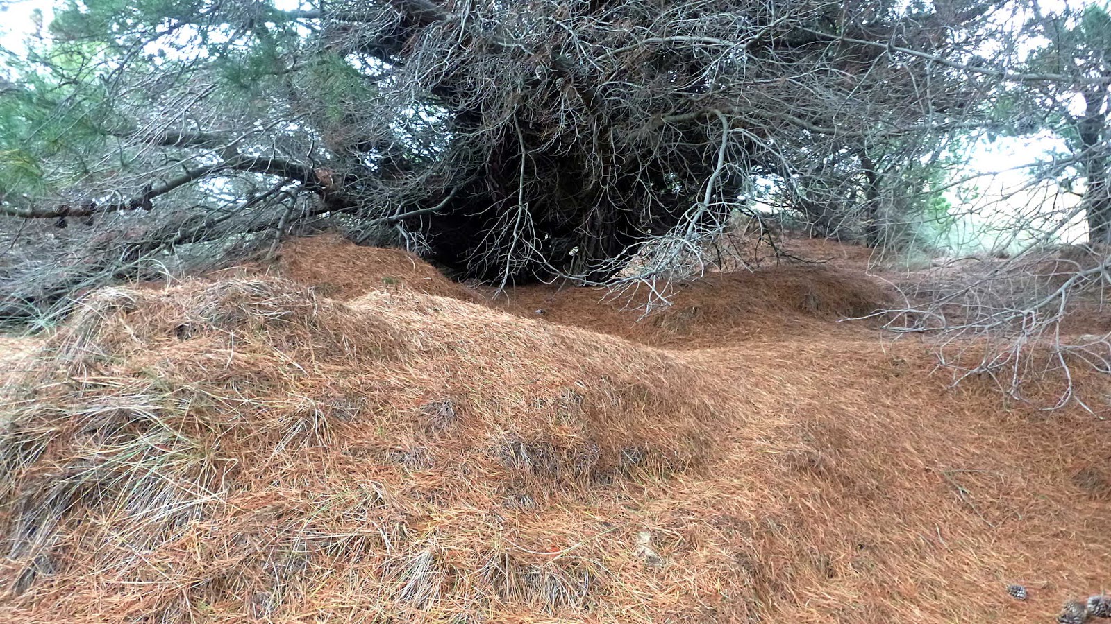 |
| Quite pretty to walk around in here |
I return to the beach, walking back to join the others. A little fine rain appears, but not enough to encourage me to don waterproofs.
Not much interesting debris on this beach (except for plastic) which one of our walkers is picking up.

 |
| I do spot a goose-stepping local |

 |
| Arrangement by Nature |

 |
| We still have a fair way to go to reach the point |
 |
| Looking back, the weather has changed |
It doesn't appear that it will affect us as it's heading north. Besides, there's a rainbow to the left.
 |
| Walking around the point to Five Mile Beach |
 |
| Lewisham and Dodges Ferry are on the opposite shore |
 |
| We pass a large dune, but Bob tells me they used to be much larger in days past |
 |
| Looking for Lunch |

 |
| Peggy has found a good spot, high above the beach |
 |
| The view |
 |
| The others have done well also |
 |
| I always try to maintain a cheerful countenance when I'm with the group |
Lunch finished, Bob finds a track leading parallel to the beach. One problem with Five Mile Beach is the number of fallen trees blocking the beach. The tide is high leaving us no room to go around them.
 |
| Heading west |
 |
| One of many blocking the beach |
 |
| This area is a pine plantation, and it's been harvested |
Original private freehold in the 1800s A Mr. Darling thought it would be a good place for forestry and planted pines in 1925. In 1927 holdings of Mr. Darling and Mr. Lewis were bought by a pulp and paper company for a pine plantation.
Australian Newsprint Mills, now Norske Skog acquired the rights to the timber, but no responsibility to revegetate or manage the logged areas. The timber was, in this report, going to be progressively removed until 2010. A 2008 report recommended continued use as pine plantation.
In 2008 Clarence City Council approved an application by Sanbar Pty Ltd to extract sand for the building industry.
Other activities have or are taking place here. Triathlons, and in 1950 the Southern Motor Cycle Club and the Light Car Club (Launceston) held time trials and beach races here with a field of 30 bikes and 10 cars.
Of course you can't leave an area like this to the will of the people, so sand mining has been proposed a number of times and a golf course plus homes have also been on the cards. I'll come to that a bit further on.
There was also, back in 1946, a crash of an Australian National Airways DC3 on take off into the water off Seven Mile Beach that killed all 21 passengers, 3 pilots and a stewardess.
You can read the article in the Mercury at the time by CLICKING HERE.
Returning to the walk, we reach the car park at the end of Five Mile Beach and walk out to Pittwater Road for our trek back to the cars.
 |
| Pittwater Road to Surf Road and our cars |
We tended to spread out a little and along here Alex spotted a couple of raptors in the distance. I stop to try and take a photo (not successful) and ended up well behind the others.
I was not alone, however, as Gerard had joined me and we continued on.
As we were walking a white SUV stopped on the other side of the road and the driver called out asking if we were a walking group and if so what we were called.
The two of us walked over and had a conversation with the gentleman and his wife(?). I started out by telling him we're a bushwalking group from U3A Kingston.
He looked confused and I hastened to assure him we weren't some sort of hippy group, but the words University and third age didn't mean anything to him. He first thought we were part of the Uni of Tas.
He did pick up my accent, but failed badly when he asked if I came from Florida! Fighting my initial response to this insult, I told him where I came from - Maryland - and not where he should go.
To cut a long story short, he's a developer who wants to build a golf course here and maintain it also as a place for walkers, dog walkers and horse riders. I can't quite see all those existing peacefully with people paying to play golf as we walk around and across the course. This sounds just like the scheme for South Arm.
The gentleman then said that there would also be a charity set up, not related to the Catholics. I don't know if he thought U3A was a church based group or not, so I'm not sure where that came from.
He really stopped us because he wanted to get the locals on side for his development. It was his bad luck to stop a Yank and a Frenchman from a group located well on the other side of the River!
I finally had to peel away as the others were small dots in the distance, turning off to reach the cars.
Keep an eye out.
We had 14 walkers and covered 17.69km in 4:55hrs. A bit of a slog as far as I'm concerned and I probably won't schedule this again. There are other walks in this area that would be more interesting. I did like the dunes at the point, though.
Click here to download GPX file

Thursday, 15 March 2018
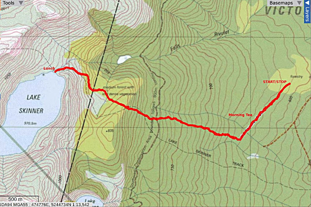
Lake Skinner 2018
Today Bob is leading us into Lake Skinner, a walk I had read about but not done.
It's about an hour and a quarter travelling from Kingston, much of that on forestry roads past Judbury.
The weather isn't bad as we turn off to the entrance to the track, parking in the space provided.

The track had work done on it back in 2015 and is clearly marked as we set off.

I query the 3 hrs return to Lake Skinner, I suspect the same person also wrote the directions to the start in the online Parks & Wildlife pamphlet in which they tell you to take Russell Road out of Judbury. Good luck with that. I suggest Lonnavale Road instead. I have since found out it used to be known as Russell Road, but not on any map I have. Or can find online.
I have seen other blogs where they claim to have reached Lake Skinner in 1.5 hours while carrying blow-up boats and other equipment, but I remain sceptical.
Putting these things behind us, we set off.

Which is 4-5 hours return, 6.5km and hard.


The area has been logged in the past, but there are a few big trees left.
It's wet and everyone is on the look out for leeches, but I don't believe anyone had one.


We come to a boot washing station. For anyone overseas, these stations have brushes to clean your boot soles and a spray to control the spread of Phytophthora root rot fungus.
Everyone clean, we move off. As we go, I keep my eye out for any interesting fungus growing along the track.


There are more rocks to make our way over, some quite large.
We're really roughing it now.
The photos below show some of our surroundings.


We start our climb, crossing the old track according to the map.


I've never seen them this high, the ones I've seen have been much shorter.

On we go, climbing all the time until we reach the top of the ridge.


Rock hopping now, good for the legs.

I'm told Bob answered "Just a hop, skip and a jump". All good bushwalking terms.

Bob was right!

It's too bad about the low cloud because it obscures the view of Snowy South over there somewhere.
It's a light drizzle and everyone has donned their wet weather gear, and we retreat to the shelter of the large rock for lunch.
It's only when leaving I realize the outlet of the lake is just over there, this is the top of the Falls Rivulet. Next time I'll know and explore.
Back we go, following the track which is marked by some faded orange ribbon.


Behind as usual as I take photos, I catch up to this sight. A wealth of walkers on a wooden plank. I still don't know what was really going on.


Soon we're back at the cars.
We had 14 walkers and covered 6.7km in 5:38hrs. This was a great walk, even with the cloud. I was asked if it will become a regular walk in our repertoire and the answer is yes.
The climb to the top of the first ridge isn't all that steep, just a lot of rocks to get over.
The height of Lake Skinner is 970 metres this roughly equivalent to Big Bend on Mt. Wellington.
Click here to download GPX file


It's about an hour and a quarter travelling from Kingston, much of that on forestry roads past Judbury.
The weather isn't bad as we turn off to the entrance to the track, parking in the space provided.

The track had work done on it back in 2015 and is clearly marked as we set off.

I query the 3 hrs return to Lake Skinner, I suspect the same person also wrote the directions to the start in the online Parks & Wildlife pamphlet in which they tell you to take Russell Road out of Judbury. Good luck with that. I suggest Lonnavale Road instead. I have since found out it used to be known as Russell Road, but not on any map I have. Or can find online.
I have seen other blogs where they claim to have reached Lake Skinner in 1.5 hours while carrying blow-up boats and other equipment, but I remain sceptical.
Putting these things behind us, we set off.
 |
| Start of the track |

 |
| This sign is closer to the truth |


The area has been logged in the past, but there are a few big trees left.
It's wet and everyone is on the look out for leeches, but I don't believe anyone had one.


We come to a boot washing station. For anyone overseas, these stations have brushes to clean your boot soles and a spray to control the spread of Phytophthora root rot fungus.
Everyone clean, we move off. As we go, I keep my eye out for any interesting fungus growing along the track.

 |
| Evidence of work done in 2015, raised walk ways across wet areas. |
 |
| You tend to watch your feet as you climb |


There are more rocks to make our way over, some quite large.
 |
| Geoff walking past a couple of Pandani |
 |
| Later, I have to go on hands and knees under a log |
 |
| Morning Tea... |
 |
| ... but nowhere to sit |
The photos below show some of our surroundings.
 |
| Mossy garden covering large rock |

 |
| Climbing Heath - Prionotes cerinthoides |

We start our climb, crossing the old track according to the map.


 |
| The track can be a bit wet |
 |
| A group of Pandani, or giant grass tree |
I've never seen them this high, the ones I've seen have been much shorter.

 |
| They can grow from two to twelve metres or six to 40 feet |
 |
| The size I usually see on our walks |


 |
| Looking back |
 |
| We're getting higher now |
 |
| The distant ridge has cloud on top |
 |
| Over the ridge and starting down, we pass large rocks dumped here in the dim past |
 |
| Alpine area and the cloud is getting lower |

 |
| Looking east |
 |
| This is what the track looks like now |

 |
| In answer to the question from someone, "Are we there yet?" |

 |
| Just around this large rock is a surprise |
 |
| Lake Skinner |

It's too bad about the low cloud because it obscures the view of Snowy South over there somewhere.
It's a light drizzle and everyone has donned their wet weather gear, and we retreat to the shelter of the large rock for lunch.
 |
| Lunch |
 |
| Falls Rivulet |
 |
| Beginning the trek back |
 |
| The small logs provide a balance exercise |

 |
| Heading back down |
 |
| Contrasting trunks |

Behind as usual as I take photos, I catch up to this sight. A wealth of walkers on a wooden plank. I still don't know what was really going on.


Soon we're back at the cars.
We had 14 walkers and covered 6.7km in 5:38hrs. This was a great walk, even with the cloud. I was asked if it will become a regular walk in our repertoire and the answer is yes.
The climb to the top of the first ridge isn't all that steep, just a lot of rocks to get over.
The height of Lake Skinner is 970 metres this roughly equivalent to Big Bend on Mt. Wellington.
Click here to download GPX file
 |
| Overview of Lake Skinner |


Subscribe to:
Posts (Atom)