As usual all the weather forecasts the previous week had us prepared for rain.
As usual when we're on the Eastern Shore, you can see the weather around and on Mt. Wellington plus the suburbs north & south of Hobart.
As usual we had no rain, but good temperatures and even sunshine for lunch. Bob must be making some weather god very happy!
After passing through Lauderdale and turning off onto Rifle Range road, we continued to our usual parking area on the corner with Gellibrand Drive.
I
DID NOT forget my GPS tracker this time, and even started a track on my phone to compare distances. (They agreed.) The road was straight and flat from the start, and by the time I looked up from all my instrumentation the others were a cloud of dust in the distance. I finally got close enough to hear David encouraging the others to speed up. I think this was an example of irony.
 |
| Car Park |
 |
| Stepping out! |
During the first 1.5 hours I reckon I made at least twice the speed of everyone else as I had to catch up after each photo. I would make note that the report also says we had a maximum speed of 6.78km/h! That would be me.
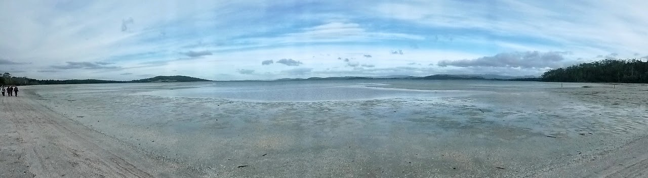
The road leads down to a shelly beach on Mortimer Bay which provides not too difficult walking as it's much firmer than sand. It is, however, about 2.25 km long. We turnoff before the no dog area and take to the trees for a short walk to Morning Tea at the June Graham entrance to the Mortimer Bay Reserve. Convenient rocks provided a place to sit.
 |
| Shelly beach on Mortimer Bay |
 |
| Mt. Wellington - you can't get away from it. |
 |
| As you can see, the tide is out. |
 |
| Rare frontal photo. Carol demonstrates our secret sign, the answering sign is to point in the opposite direction. This can be very spectacular if several of us meet at once. |
 |
| Still going |
 |
| Someone way back there, but not one of us. |
 |
| Morning Tea |
 |
| Serious business |
|
|
 |
| Weather building over Wellington |
 |
| Ducks in a tree. by Carol |
 |
| Reflections by Carol |
The way leads south and after a short walk on a sandy and sometimes flooded road, we turn off and travel through scrub along a track that parallels both the bottoms of properties and the foreshore. This is pleasant walking with no uphill surprises (yet).
 |
| Foreshore track |
 |
| Walking among She Oaks |
 |
| I must get a field guide to Tassie flora |
 |
| This will have to do as the art shot |
 |
| These were growing in one section of the track |
Eventually we have to turn off and go up hill to catch Gillibrand Drive and walk a short distance before entering the bush again. Before we do that, we pass a property I remember from previous walks, and the photos below show how it looks now, and what is hidden in the shed. These older photos are from a couple of years ago.
 |
| Who knows what lurks inside! |
 |
| I wonder if they're trying to say something? |
 |
| This is inside, and to think I settled for a ride-on mower |
We finally launch back into the bush, to walk down between properties, where we met a rather pushy Jack Russell who insisted someone reach through the fence, pickup and throw his tennis ball.
It managed to train David to do this in about 5 seconds.
We follow this sandy track around through the bush, past some emus who were not too friendly, and back to the Morning Tea spot for lunch. Someone made a comment about everyone being able to talk to each other now (the track was mostly single file), whereupon someone else else -who shall be nameless- said "You've been talking for 9km!". This immediately set the pigeon among the cats (no offence) and he was well and truly told.
 |
| Something captures Carol's interest |
 |
| A Bottlebrush. I bet Carol's photo is better than mine. |
We found this beside the track, a bony plate with several bones still attached. We don't know what animal it is, the discussion turned to Wombats as they have a bony protective plate in their rear. They use this to block their burrow and protect themselves. Any suggestions would be appreciated. If NASA can give us some information from their secret programs, that would be good, too.
 |
| Wombat? Alien? by Carol |
 |
| Back for lunch, Bob's looking at a recipe book. A bit late now. |
Lunch finished, we took a slightly different track north, passing through more trees and an open area, turning right and continuing back to the paved road.
Walking along a track beside the road, Bob lulled us into a false sense of security by dodging right, then declaring it was the wrong place and returning to the original track. This cunning move confused us, so we didn't immediately take note when we turned off again and found the second, longer, steeper, sandier hill. It's popular with horse people (these are actually separate horse & rider, not some Tasmanian cross breeding) 2 of whom we met riding down. It was only after they passed I came up with the idea of offering money for them to turn around and tow us up the hill, but it was too late.
We finally crested that last hill and took another track that led across and down to, you guessed it, Gillibrand Drive. A walk of just over 600 metres brought us back to the cars, and the 2 ladies on horse back whose float was parked just behind us.
 |
| Up we go, and aren't we happy |
Altogether a very enjoyable walk was had by all. Good weather and a variety of surroundings made it interesting.
We had 10 walkers and covered 13.9km in 4 hours.
Click here to download GPX file