Today Bob's taking us on a new walk on the Rokeby Hills above Tranmere on the eastern shore of the River Derwent.
The weather is o.k. when we arrive at the parking but is supposed to fall apart later in the day.
We park at the end of a little linear park I recognize from other walks in the area and set off down hill.
 |
| We'll be crossing the road to start |
 |
| Minerva Park |
Walking down through the park, we eventually find our way to the shoreline and the combined track. Now, we're heading towards Droughty Point.
 |
| Beautiful winter weather |
 |
| Hobart and Mt. Wellington |
 |
| Droughty Hill in the distance |
 |
| More houses every time we walk here |
After a while, we turn off the track to head towards Rokeby Hills. This is via Rotuma Park and Carella St. There is a well hidden public right of way between 222 and 224 Carella St. According to List Maps, this is called Elinga Play Park. This takes us up to Oceana Drive and a short track into the hills.
 |
| Up Carella Street |
 |
| Sign in bushes |
 |
| The track between 222 and 224 Carella Street |
 |
| Start of the reserve |
 |
| Entering the reserve |
We climb up, bearing right to find a spot for Morning Tea. Fairly open bush, so seating is no problem.
 |
| Morning Tea |
 |
| The track ahead |
As we came to find out, there are dozens of tracks running over the reserve, from large to very small.
Tea finished, we head south, catching a view along the way.
 |
| Looking towards Tranmere Point |
 |
| Very open bush at this point |
 |
| We're not sure what these mounds are, not graves as was suggested! |
I first thought it was dumped landfill, but they appear to have been built by scooping out soil on site. We'll find more of these in a little while.
 |
| Droughty Hill... |
 |
| ...with a flag on top |
At this point, we loop around and begin to head north again. I'm behind at this point, and I catch up to Ron and Wayne looking at, what first appears to be, an old construction. What appears to be grout lines are actually part of a solid lump of rock, about chest high. Next to it is a large flat rock that looks like it was put on top of smaller rocks to level it. How they got here and why is a mystery.
 |
| Mystery rock |
The others have continued on their way and a jogger also passes us as we set off to catch up.
 |
| Ralphs Bay and Rokeby Beach |
 |
| Clarence Plains Rivulet |
 |
| More housing to come |
 |
| Eastside Activity Centre |
 |
| Looking towards Lauderdale |
The track narrows and we come across more mysterious mounds. They continue out of sight in a straight line, crossing the track. I don't think they were put here for mountain bikers, if they were then no one is using them.
 |
| Uphill |
 |
| Downhill |
Again, they appear to be constructed from soil on site rather than dumped. While taking these photos, the others continue on the track below, but I manage to catch up by tracking the sound of conversation.
 |
| The track grows more faint |
The next time I stop, the track is as above, and I spot some interesting fungus, one of which is the only survivor of numerous large feet passing nearby.
 |
| The only survivor |
 |
| Nearby |
Unfortunately, this time the rest of the group has walked beyond both sight and sound. Never mind, I've tracked them before. I walked on, following the track until it came to a larger one. Faced with several choices, I apply logic as to where Bob would have taken the rest. Not downhill, too easy. Uphill, possible but too large a track. Cross over to the small track on the other side? That must be it, so over I go.
I soon reach another junction of several tracks and decide it's time to stop and make a noise. I pull out my -advertised as the loudest in the world- whistle and give it a hard blow. No answering cry, but a couple of minutes later my phone rings with Wayne on the other end. I find out they did go downhill but by other tracks and Bob is walking back towards me. I turn around and blast my whistle again. Unfortunately Wayne copped it full in his ear even though I lowered my phone. To cut a long story short, I soon spotted Bob standing just uphill from me and he led me back to the others.
On we go to find a spot for lunch, passing a traditional Tassie graveyard that occurs anywhere in the bush near suburbia.
 |
| Back to the bush |
It's not long before we find a good spot for lunch.
 |
| I did standby with camera ready as this fallen tree filled up with sitters |
Fortunately or unfortunately depending on your point of view, it held.
 |
| The rest of us took a safer option |
After lunch we took off again, following a track traversing a fairly steep slope. Signs of mountain bikers all around.
 |
| Scrubby bush all around |
 |
| Across the slope |
 |
| A couple of views show the weather is changing |
 |
| Howrah below |
 |
| The track loops around and we take off up hill on a smaller track |
 |
| New track is very faint on left |
 |
| I grab this photo of a group of fungus |
At the top we come out on a fire trail and head left.
 |
| The fire trail |
 |
| Houses with Rokeby Road below |
We leave the fire trail to walk up behind the houses and back into the bush.
We start down a track before turning around to take a smaller track we had passed.
 |
| Not this one! |
 |
| This one! |
As we follow this track around to head back south, we come across some old stone constructions. Some seem to head up into the bush and may have been old walls. I can find almost nothing about the history of this immediate area.
 |
| Possible stone wall |
 |
| Ramp to nowhere. Neglected private mountain bike ramp |
 |
| We pass behind the houses |
Soon, we find a track down to a set of steep steps with bright blue railings. These take us out of the Reserve and onto Fairisle Terrace.
We make our way down until we enter Carella Park, crossing it into Carella Street which takes us back to Minerva Park and the cars.
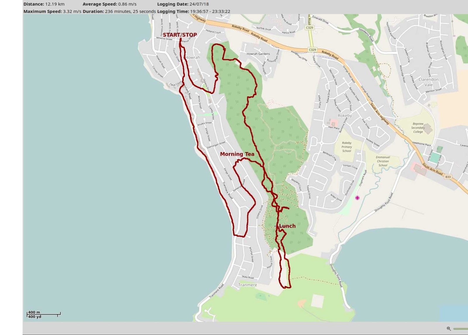
We had 12 walkers and covered 12.19km in 3:56hrs. New territory and interesting walk with lots of scope for more walks due to the many tracks and trails.
Click here to download GPX file
This week was a fairly convoluted track for various reasons. If you want to see an animated track,
CLICK HERE.
The animation shows the hesitations of Morning Tea and Lunch.


No comments:
Post a Comment