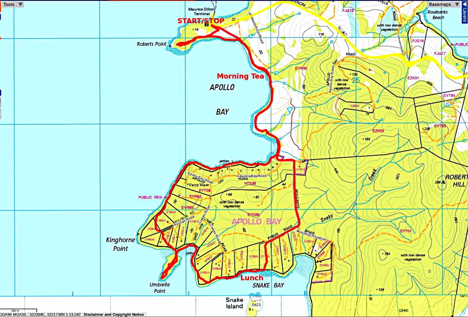
Today we're heading over to Bruny Island via the ferry from Kettering to walk to Umbrella Point (and back).
I'm the nominal leader and have decided to conduct the walk backwards. That is, in a clockwise direction rather than a counterclockwise one.
I walk from home to Kettering to the ferry terminal and the rest of the group soon appear. For anyone's interest, Woodbridge to Kettering Terminal is 5.5km using the footpath from Trial Bay, and took 53 minutes.
The day promises to be a warm one with forecast of 27C, but is overcast at the start.
 |
| Umbrella Point across the D'Entrecasteaux Channel |
 |
| Our Ferry at the Bruny side |
We board the ferry and climb up to the top deck for the trip over
 |
| Kettering Marina and cafe |
 |
| Loading hasn't started yet |
 |
| Looking across Little Oyster Cove |
 |
| An old sea dog |
He turned up to join us up top. Loading started and we tried to pick out who was a Bruny Island resident returning to the island and who was a tourist.
Tourists were fairly easy to pick as they were largely Chinese. I think our group will appear in a Chinese travel magazine as a gentleman in a photographers vest took our photo with a large camera.
I hope they all enjoyed their day.
The trip to Bruny was uneventful and calm.
 |
| Looking north up the channel towards Hobart |
 |
| The second ferry |
Sealink have just taken over running the ferries and is in the process of building two that will replace the double decker we're traveling on and the landing craft above.
Much controversy as the two new ferries will be single deck and smaller than existing boats. They are also going to introduce a booking system, which is not popular with anyone on the island. Or anyone else who travels to Bruny.
 |
| Salmon farm not far from the Bruny Ferry Terminal |
Construction is taking place of a new waiting lane to take more cars, so we have to make our way through a building site to find the small gate at the start of the walk.
Soon, civilization is left behind as we head off.
 |
| I let them get ahead of me to scare any snakes away. Actually, I had trouble getting my GPS tracker to log on. As in many things in life, switching it off and on fixed the problem! |
Up ahead in those gum trees is a large Sea Eagle nest that appears to be several generations old, judging from the size.
 |
| Sea Eagle's nest in top of large gum tree |
We had a look around as there was no activity near the nest, but one was spotted drying its wings in a nearby tree.
 |
| Drying its wings |
 |
| Definitely an Eagle |
Leaving the bird behind, we make our way down to the northern end of Apollo Bay beach to find a spot for Morning Tea.
 |
| Apollo Bay north |
 |
| Morning Tea with free seating |
 |
| The rocks here are very different from the other side of the Channel |
Tea finished, we make our way back to the track which runs along the Public Reserve along the foreshore. It's up and down here and as we start on the next short descent, Lorna and I spot a a local in the distance. It appears to have a joey in its pouch, but a closer photo revels only its paws.
 |
| Not a mother |
Apollo Bay is becoming popular for new homes, and as we travel south there are more under construction.
 |
| New construction with another behind |
We did see a workman in a paddock, but his shovel appeared to be designed more for leaning than digging.
We reach the southern end of the bay and walk up a short track to Apollo Bay Road. Usually we turn right here, but today we're going backwards and turn left, heading for the right turn into Mulcahys Road.
 |
| Someone's been busy planting |
 |
| Mulcahys Road |
 |
| Looking back |
 |
| Dry bush off to the side |
We continue down, heading towards the water and a turn onto Pybus Road. I can remember we came up a track from the shore here just a little way along in the past.
Everything has changed with a new fence and gate (locked) bulldozed land and a dam. We head up Pybus Road which becomes a turning circle at the top.
There is an old track before the end that appears not to be used, but Bob offers to check the top and see if any other track will take us to the water.
 |
| Peter watches Bob set off... |
 |
| ...Peggy's not too sure... | |
 |
| ...and the rest don't care |
 |
| We decide to make our way up and find that Bob has found a track. Of sorts |
We head off through the clear bush towards the water. A couple of flowers catch my attention along the way.
We finally reach the shoreline opposite Snake Island and enter the reserve along the shore.
There's a bit of a theme taking place here. We're on Snake Bay, that's Snake Island in the photo below, and there is a Snaky Creek nearby.
No wonder I keep an eye on my feet!
 |
| Snake Island |
 |
| Snake Island Reception Centre |
We make our way along the rocky foreshore looking for a lunch spot.
 |
| Western shore of the D'Entrecasteaux Channel |
 |
| Lunch with comfortable rocks and a view |
 |
| Looking southwest |
 |
| Looking south |
 |
| Getting ready to start off again |
We continue on following the shore towards a small, unnamed bay.
 |
| Umbrella Point just over there |
We continue on, walking north to make our way around this small bay.
 |
| Bob finds an addition to the shore that wasn't here last time |
 |
| I don't know if this is accommodation or a secret base. It's been there for several years |
 |
| We're on the peninsula now and making our way to the tip |
 |
| Sparse vegetation and few trees |
 |
| Woodbridge Hill with the village below |
 |
| Silverwater Park. I live behind the trees along the shore |
Surprising how many people believe I live in the trees.
 |
| The tip of Umbrella Point or Single Tree Point |
After admiring the views, we make our way back. Usually we head right, back along the beach to a track that leads up to Lowes Road. Today, however, Bob wants to explore the other direction. This is something I've looked at only on Google Earth, but what the heck, we'll give it a go.
 |
| Setting off to make our way around Kinghorne Point |
There is a reserve following around the shoreline, which we try to keep to. There are no tracks, or at least, none made by humans. If you have a pouch and a tail you'd be o.k.
 |
| Regrouping |
There is a variety of vegetation along the way, from grass to she-oaks, all of it dropping steeply towards the shore.
At a couple of points we find ourselves on the shore, and on the last part we follow what is now a Public Reserve around to a set of well made steps that lead up.
Heading left at the top takes us back down to the bottom of the track we left the beach on in the morning.
 |
| Back at Apollo Bay |
 |
| Making our way back to the start |
More flowers appear on the way.
The ferries run every half hour, but this is not the reason that we step out on the way back.
It's traditional that on our trips to Bruny Island that the walk ends with a visit to the little shop at the Ferry Terminal for ice cream, so unless we want to wait for a later ferry, we have to make time to enjoy our treat before we have to leave.
We make it in plenty of time, so much so that some talk of having seconds.
We catch the ferry and head back to Kettering. I walk the footpath back to Trail Bay where I decide it's going to be too hot to continue to Woodbridge. So I call Val to come and rescue me and find her waiting when I get there.
An interesting walk, and I'm glad, on looking back, that Bob took us around on the new route. It could be included in a new walk in the future.
We had 10 walkers and covered 11.69km in 4.04hrs moving time. When the Sun came out it became quite warm, but luckily most of the day was overcast.


No comments:
Post a Comment