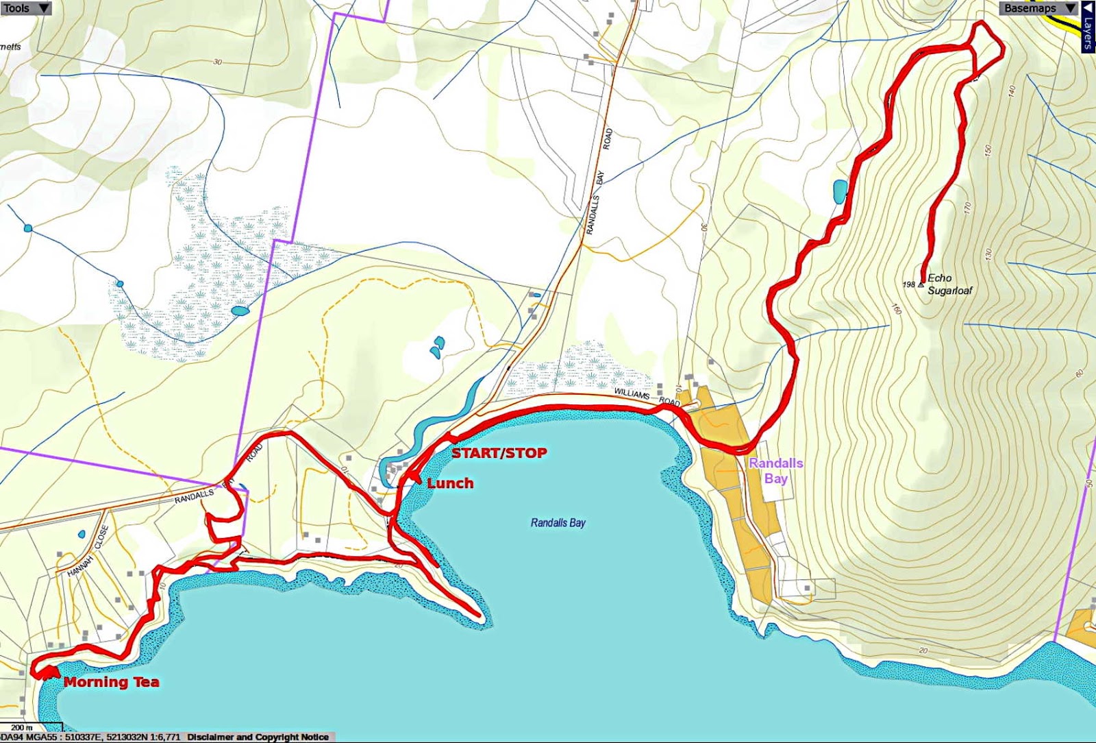
Today is a walk from Randalls Bay to Echo Sugarloaf and to say the weather is fine is an understatement.
I've been looking at maps online and drawn out a track that I've downloaded to my GPS, hoping to blame technology if we get lost.
We didn't.
Parking at the beach, we set off following Randalls Bay Road looking for a small track I spotted on Google Earth.
 |
| Ready for the off |
 |
| Randalls Bay Road. Traffic isn't a problem |
Someone spotted what appeared to be a bird's nest attached to the top of a post with a roofing screw. What it actually was is a mystery as it had no depression for eggs on either side. I suppose I should call it a two part mystery, the second part being why anyone went to the trouble to screw it to the top of the post.
 |
| Mystery nest thing |
On we go and technology proved correct when my GPS indicated the little track I was looking for on the other side of the road.
 |
| Into the bush |
The track widens farther in as we enter an area that's been mined for gravel in the past. Bob reminds me we've been here before on a walk to Eggs and Bacon Bay, which I've completely forgotten.
 |
| Looks like someone has been digging a home below the tree |
Getting closer to the coast, the views begin to appear.
 |
| Garden Island in the distance |
It's about that time, so we begin to look for a place for Morning Tea.
There's a track that drops down over the cliff, taking us to a place where someone parks their dingy. There's also a little isolated beach that looks perfect, so down we go.
 |
| Heading down |
The track brings us to this large log. Gaining the beach requires a leap of faith.
 |
| I was told my exit from the log was the least elegant. Careful what you say about the bloke who takes the photos and writes the words! |
There's a likely log here, but part of the group move farther up into the sunshine.
 |
| Morning Tea |
I have a look around and take some, of what I used to call, art shots.
 |
| Fascinating eroded rock formations along the beach |
 |
| Garden Island |
Yes, there are houses on the island. Even a Garden Island Road marked on the map.
 |
| A small ex-crab on the beach |
Morning Tea finished, we make our way back up to continue along the track, heading towards Randalls Bay Beach.
 |
| Climbing back up |
After a short distance, we drop down to another beach, walk along and climb back up.
The track is well marked, something new from last time.
 |
| I have no idea who Mickey was nor why he had a beach named after him |
Returning to Randalls Bay, we walk out onto a point giving great views in all directions.
 |
| That "little hill" as Bob calls it is our destination, Echo Sugarloaf |
 |
| The end of the point we've walked out to |
 |
| Two of our walkers soaking up the tranquility and beauty of this place. Photo by Peter |
On we go, climbing down the track to the beach and lunch.
 |
| Going down |
At the bottom is another track leading towards the point. This was the Randalls Bay Tramway. Before lunch, we walk out.
There were coal mines around Mt. Cygnet, Randalls Bay, Deep Bay etc. I suppose it was shipped out of here.
 |
| Site of the old tramway |
We make our way back and up the beach for lunch at the covered BBQ.
 |
| Lunch |
Afterwards, we walk up the beach towards the beginning of the track climbing Echo Sugarloaf. There are few people around, mostly dog walkers.
 |
| We'll walk along the beach |
 |
| At the top of the beach, we turn onto Williams Road |
A short walk up the road past the shacks takes us to the start of the track.
 |
| I didn't expect steps |
 |
| Looking back |
 |
| Now we're on the track proper |
The track is a project of the Friends of Randalls Bay Coastcare Group and was opened last year.
You can read the interesting background story if you
CLICK HERE.
They've really done a great job on the project and it's well worth walking. The track winds around and there are no real steep bits if you're worried about that.
 |
| Looking up. Now, that is steep... |
 |
| ...but this isn't |
Along the way you come to a pond and a viewing platform has been built here if you want a break.
 |
| The pond |
 |
| It's even stepped to provide a seat if you require |
On we go, heading steadily up.
 |
| We head up and around the false summit |
 |
| The track. Grassy at this point |
 |
| We re-enter the bush for the final stretch to the top |
 |
| The final short scramble to the top, it's a bit rocky now |
 |
| Made it! The trig marker marks the top |
We spend some time enjoying the views.
 |
| Adamsons Peak in the Hartz Mountains National Park complete with patch of snow | |
|
 |
| Esperance Peak |
 |
| Local trying to sunbathe. Sorry mate |
 |
| Rather out of the way place for a political comment |
 |
| Must be something about the air up here that upsets people. Anyway, I hope they can afford to complete the return loop as it would make a great walk better |
Time to leave, so we head back down the track. It's not long before I sense a shortcut coming.
 |
| Looks like the track is down there |
 |
| Find a shortcut and they're off like lemmings! |
We return to the cars the same way we came up.
This is a beautiful area and the Friends have done great job with the track. I can recommend it to anyone.
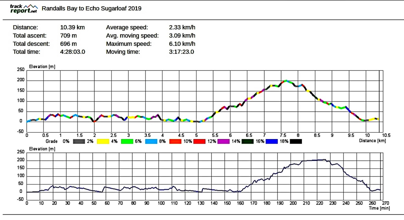
We had 17 walkers and covered 10.39km in 4:28hrs. It's a great place to take your time and enjoy.
Click here to download GPX file


No comments:
Post a Comment