Today Bob is leading us on an extended walk up Snug River, but first we're going to walk around Electrona/Peggys Beach just to get warmed up.
We park at Snug Beach just near the caravan park.
 |
Almost ready for the off
|
After gaining the attention of the group so Bob can brief them, we set off north towards the mouth of the river. However, we're not going to walk up the river now, but cross over and take a track around the coast.
 |
Over the bridge
|
 |
Looking up Snug River
|
 |
Snug Beach
|
 |
Onto a new track
|
 |
Heading down to unnamed beach
|
 |
Children of all ages enjoy a tyre swing at the beach
|
 |
Heading north
|
 |
Looking at part of a fish farm
|
Perhaps this one of the ones involved with the great escape of Atlantic Salmon in the last couple of weeks and is being repaired.
 |
Typical Salmon Farm from the air
|
It's a very small beach and soon comes to Peggys Beach and marina where we turn inland for Morning Tea.
 |
Peggys Beach
|
 |
| Morning Tea |
|
 |
We're heading south towards the river
|
Soon we enter some bushland to follow tracks back to Snug.
 |
Crossing a gully
|
 |
Up a slope and we're on an original stretch of the Channel Highway
|
No cars travel this section now and it's used as a cycle path heading north to Margate.
We go down, heading for the start of our river section.
 |
Over the bridge to Snug with the Primary School on the right
|
 |
Start of the track
|
There were some large blackberry bushes laden with large, juicy berries that were popular with some of the group. Unfortunately, the sign below was put up on a tree after the bushes. Hope everyone felt well after the walk!
Oh well, enjoy it while you can.
 |
Start of the track
|
 |
Looking back
|
 |
The river's to our left and down
|
 |
Being summer, there's little water flow
|
 |
About to go down
|
 |
The river below
|
 |
A fairly steep descent where...
|
 |
...some find the bottom technique to be the best option
|
 |
We can see the river now, such as it is
|
 |
Another obstacle to overcome
|
 |
| In among the Manferns (Dicksonia antarctica) |
It's flat walking now and we run into a young couple walking their shy dog.
On we go through very pleasant bush.
 |
Crossing the river. I did say it was dry!
|
 |
Mendelt hoping for an exciting photo
|
 |
The river, on our right, is blocked from view by this large, long pile of boulders
|
I may be quite wrong, but I wonder if this was the result of the cleaning of Snug River due to flooding back in 1973. If you have a spare couple of days you can download a study done by Kingborough Council in 2019 showing the flood problems they had back then with photos. If you need help to fall asleep just
CLICK HERE and read the pdf file.
 |
We're getting close to our lunch and turnaround spot
|
 |
| Lunch |
 |
By a pleasant pool
|
 |
Ron has found a comfortable stone armchair for lunch
|
After lunch, I walk upstream for a short, rock hopping distance just to have a look
Everyone is ready to leave so I hurry back to join them on the trek to Snug.
 |
Start of the return journey
|
We pick up a track on the southern side of the river which will take us back to the Channel Highway.
 |
New track
|
 |
Goodbye to Snug River
|
 |
Bracket fungus
|
Back to civilization, we turnoff and head up a right of way leading up to Taranaki Place through fairly new houses to Snug Tiers Road. We cut through St. Marys Church Cemetery to reach the Channel Highway again. Here we head south to the Esplanade next to the Service Station which will take us back to the cars.
On the way we stop while Bob checks out a track close to the water, but the tide's too high for us to take it, so we continue on to reach a set of steps that leads us down to where the cars are parked.
 |
Looking towards Lower Snug
|
 |
Waiting for Bob
|
This is where Bob disappeared to check out the coastal track. While waiting, some unkind person suggested we should disappear while he's out of sight, but I'll conceal their identity just to spare the sensitive.
 |
End of the trail
|
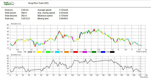
We had 15 walkers and covered 9.69km in 3:33hrs on a very nice walk thanks to Bob.
Just as a matter of interest we only had to walk roughly (VERY roughly) about 3.5-4km upstream to reach Snug Falls.
Click here to download GPX file


No comments:
Post a Comment