Today Peter is finally getting his chance to lead us on the new track linking Kingston with Taroona. It's supposed to become very warm today, but at the moment it's cool and overcast.
We park down at Browns River and set off with a rather large group.
 |
| We park along Beach Front Road and set off for the footbridge |
 |
| Browns River towards Mt. Wellington |
 |
| The last time I was here (with dogs) this was all sand |
 |
| Start of the Alum Cliffs Track |
It's a pleasant walking track, one we've been on many times before.
 |
| Looking south |
You'll get a chance to compare the weather with a similar view at the end of the walk.
 |
| Quite a few flowers around |
 |
| Photo by Renate |
 |
| Photo by Renate |
 |
| All the creek beds are dry |
 |
| View towards South Arm |
Soon we approach, what used to be, the end of the track.
 |
| About as close as you can get to the cliffs without climbing |
 |
| The view north shows one of the beaches we'll walk |
But not yet as Morning Tea calls (at 10:00!).
 |
| I pass the time photographing local vegetation |
 |
| Comfortable spot... |
 |
| ...with a view |
Tea finished, we set off towards the Shot Tower in the distance. The last time I was here they were just constructing this part of the track and we only looked down.
 |
| Our first objective, the Shot Tower |
 |
| An orchid. Best photo of a bad lot |
The only orchid we saw on the walk.
 |
| Going down |
It's a very slippery, loose surface. The 'steps' help limit falls.
 |
| Looking across to our future |
 |
| The bottom, another dry creek |
 |
| Renate takes an action photo |
 |
| We're there |
The Shot Tower is very interesting, I remember climbing it many years ago. It was used to make lead shot for firearms.
Parks & Wildlife have a web page that tells you all about it. just
CLICK HERE.
It's 58 metres tall and was the tallest building in Australia for four years and tallest in Tasmania for over 100 years!
 |
| Behind the tower. I don't know what they use the seed drill for, not much flat ground here |
Now we leave the tower and start the newly constructed track leading to Taroona.
 |
| Start of the second phase of our walk |
 |
| This could be a walk in Europe with all the daises |
 |
| Photo by Renate |
 |
| Difficult to see in this photo, but there's a small pool of water there |
 |
| There are still some large gums down here |
 |
| Elderly bracket fungus |
 |
| Looking down the fallen tree from earlier |
Not too far from the downed tree, we come back into suburbia on Wandella Ave.
 |
| Track exit onto Wandella Ave |
 |
| Pointing back |
 |
| This is where we turnoff and head down towards the river |
 |
| There are actually houses on each side |
 |
| There is quite a drop on either side of the track now |
 |
| We reach a long stair case and go down to the beach |
We're on Hinsby Beach now, and take time to look south towards Kingston. You can see the Alum Cliffs now.
 |
| South to Alum Cliffs |
The boat on the left side is the one that takes tourists down to Woodbridge and back to Hobart.
 |
| Only us here at the moment |
There will be more people when we come back this way.
We continue on our way, walking around the point on the rocks, onto another beach. We're following the Taroona Foreshore Track now.
 |
| I tried for a photo of them drying their wings, but the bloke facing me kept warning them |
 |
| Gotcha! |
We're passing Taroona Park now, and Ron spots a new friend.
 |
| I think your advances have been rejected Ron |
 |
| It's a fair way back to the Shot Tower from here |
We soon come across the site of Bachelor's grave, supposedly the oldest known grave in Tasmania, dating from 1810.
James Batchelor was first officer of the schooner Venus, who was killed trying to mend broken sails when the schooner was caught in bad weather on Tassie's east coast.
The captain carried his body into the River Derwent where a grave was dug above the high water mark at Crayfish Point. A headstone was purchased in Hobart Town and taken back to the grave site.
It lists James Batchelor as First Officer of the Venus, Eber. Bunker as Commander, and J.C. Burton as owner. the O B Jan 28th 1810 I assume is the date of death. (O b = Obit).
It's said a story in the Mercury in 1940 reported the farmer that owned the land dug up Batchelor's skull as a curio. After his family complained he gave it to a dentist friend who kept it for a few years but finally returned it to the grave.
 |
| Grave of James Batchelor |
We take the pleasant looking track north towards Dixons Beach.
 |
| The trail has a new name now |
 |
| This beach is covered with many of the shells below |
 |
| I have no idea what is attracting so much attention |
I don't think it was an orchid.
 |
| Interesting sign. It only runs for a few metres until it comes under Council control again |
 |
| Students on the beach below Taroona High School |
Now, what were those figures re literacy, numeracy and writing that just came out?
 |
| We head up here to loop back to Taroona where we left Adie |
 |
| Heading for lunch |
We return to Apex Park where Adie is waiting. There we have lunch before setting off on the return journey to Kingston.
 |
| Entering Apex Park |
 |
| Adie unaware we're behind him |
 |
| Lunch spot. Photo by Renate |
 |
| Heading back |
We arrive back at the Shot Tower and everyone looks forward to the climb.
 |
| Heading down |
Peter suggested I wait until they were all heading up, when he would call to them to wave. Not completely successful.
 |
| No waves but no rude gestures either |
 |
| At least someone made the effort |
We arrive back at the Morning Tea site, where everyone seems unwilling to continue back to Kingston. Finally, it's suggested I lead, which I do.
 |
| I stop for a couple of Christmas beetles |
Looks like a nice track. I'm well ahead of most of those behind just enjoying the walk. I stop to watch a fairy wren dance along the path.
 |
| By JJ Harrison (jjharrison89@facebook.com) - Own work, CC BY-SA 3.0, https://commons.wikimedia.org/w/index.php?curid=12075434 |
I'll blame him for what happened next. On a flat, but narrow track, edged by rocks on one side, I fell flat on my face! I still don't what I tripped on. The others arrived, pushed me clear of the track and continued on.
Just joking, no harm done just a little skin gone. I learned I wasn't the only one to take a dive. We soon arrive back at Browns River.
 |
| Notice the difference from the earlier photo? |
 |
| Unconcerned local in Browns River |
It was a very good walk, the steep bits weren't that difficult, probably because Bob drags us up any hill he can find, and the walk pleasant.
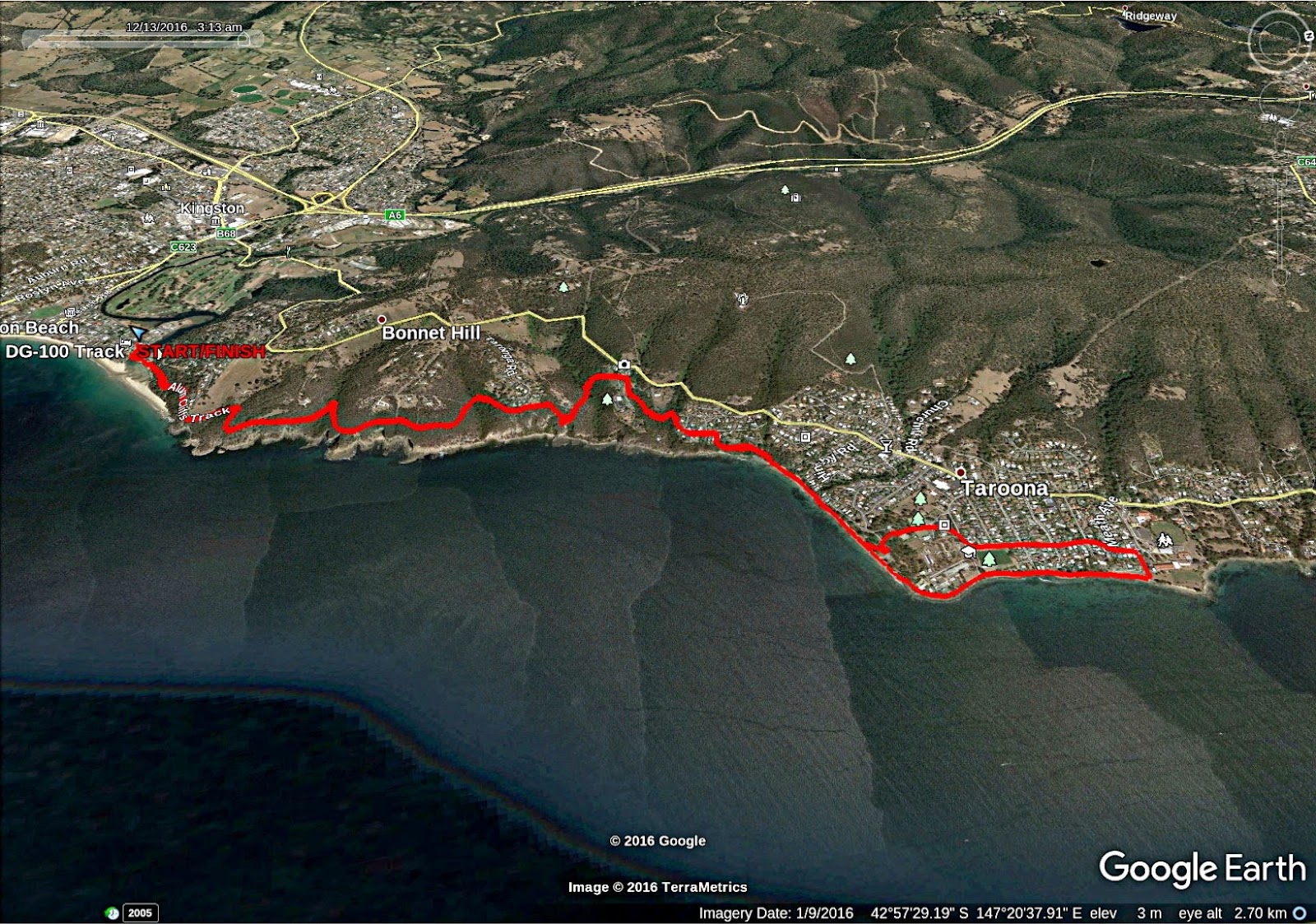
We had 20 walkers and covered 13.49km in 5:03hrs. Peter has been keeping in contact with Kingborough Council for sometime now and finally got the word the track was open. Thanks to both Peter and the Council, it's worth doing.
Click here to download GPX file


No comments:
Post a Comment