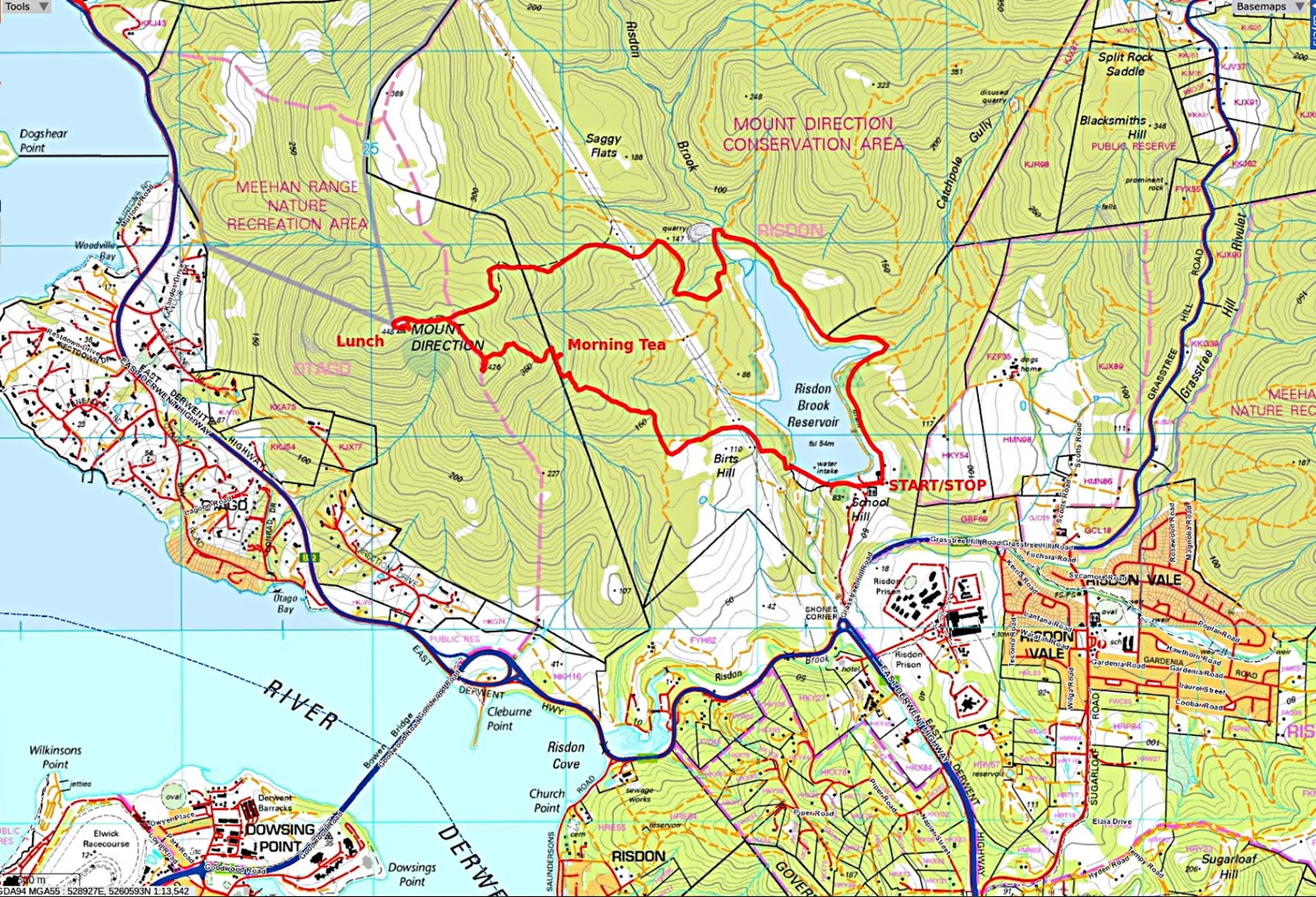
Today we're walking from Risdon Brook Dam to the top of Mt. Direction and back. This promises to be a nice little climb.
Mt. Direction was named by Captain John Hayes of the East India Company back in 1793.
The weather is clear and warm to hot as we set off from the car park.
Actually, it was 27C when we finished. That's 80F in the old money, just the day for a steep climb.
 |
| The last bit of flat walking for a while |
 |
| The destination |
Actually, I might have been a little misleading in telling people that. We'll really be going a little bit higher.
We cross the dam where new and unattractive traffic barriers and temporary/ permanent safety fencing have been installed. It did have a fence before and I don't know what caused all this health and safety nonsense, but there it is.
Reaching the other side, we abandon the track around the reservoir, heading up the old dirt track.
 |
| Looking back |
The water in the reservoir is not taken from Risdon Brook which is channelled around the dam. The reason being the water from the brook is too hard for domestic use. Instead, the water is pumped, mainly in the winter, from existing pipelines.
 |
| Looking down |
When walking this in 2015, we turned off somewhere to the left and continued uphill off track. I have that track on my GPS, but there are many more fallen trees blocking the way, so we continue following this track.
Finally, we do move off track continuing up, striking the old boundary fence and track that separates the Mt. Direction Conversation Area from the Meehan Range Recreation Area. Mt. Direction is actually located in the latter.
 |
| Reasonably steep here, I'm glad I didn't have to put up the fence as it continues a long way |
We pick a spot with a bit of shade for Morning Tea. While everyone was settled, Bob called me over to look at the plant below. While I manoeuvred to take a photo, I was accused, quite wrongly, of stepping on the tiny plant. I may have been a little close as I stepped around it.
 |
| Bob's Weed |
I've been through my reference book and can find nothing that looks like the above. So, I'm calling it Bob's Weed or
Bob scriptor Viriditas
It would have been called a flower if I hadn't been falsely accused.
 |
| We have a view of the Tasman Bridge |
Tea finished, we continue on looking for a spot to cross the fence and continue uphill. Soon we spot a couple of rock cairns, step over the flattened wire and start up.
 |
| Old boundary |
 |
| We head off track... |
 |
| ...and Bob waits for us to catch up |
Eventually, we reach the top where it's fairly level. It's here that I admit it isn't Mt. Direction and we will have some more walking to get there.
Having named a plant, I'm on a roll and call this hill Mt. Misdirection.
In the meantime, we enjoy the views from here.
 |
| Heading around the top to get a view of the River Derwent |
 |
| Looking towards Glenorchy |
 |
| The birdwatchers among us are all aflutter as they spot a....bird |
I can't identify it from my phone app, so I'll leave it to the experts.
 |
| Mt. Wellington behind the trees |
 |
| Bob borrowed my camera to take this photo |
Last place you would expect to see a pirate.
The views are mainly blocked by trees, so we set off along a faint track towards the true Mt. Direction. This intersects the marked track leading up from the reservoir to Mt. Direction.
 |
| On track for the true Mt. Direction |
 |
| Hills stretching away |
 |
| The track winds around to reach the summit |
 |
| I think that brown area is Saggy Flats |
Named so not because a lack of geological muscle tone, but because of the plant that grows there, the Sagg.
 |
| Madmans Hill and Gunners Quoin |
 |
| Convict built triangulation cairn |
Possibly constructed by James Sprent. His is an interesting story and worthy of a T.V. series.
CLICK HERE if you want to read a bit more.
 |
| Modern communications |
 |
| View from rock outcrop of Mt. Misdirection in the distance |
 |
| Lunch |
The views from Mt. Direction are spectacular and I have included some below.
 |
| Bridgewater Bridge over River Derwent |
 |
| Lift span on above bridge |
 |
| Mt. Dromedary in the distance |
 |
| Claremont below Mt. Faulkner |
 |
| An indication of the size if the cairn |
We finally start on our way down. We'll return to the reservoir by the main route, which is sometimes steep and very slippery due to loose stones, causing myself and others to go skating several times trying to maintain our balance.
We reach the track around the water and turn left to take the long way. Naturally.
We had 11 walkers and covered 8.98km in 4.0hrs. Not much but it did include climbing over a kilometre, so add 10km to that total.
Click here to download GPX file
Before I end, Ron sent me a photo of the view from the top of Direction in which, he claims, a UFO appears above the Jordan River.
 |
| Is it a bird? Is it a plane? |
Perhaps neither. As we're in the lead up to a state government election and the election promises are falling like manna from heaven, the object may show the location of a large (very large) stone tablet with Liberal promises on the right, Labour on the left, with the minor parties scrawled on the back with a marker pen.
If Bob could find a route up, we could retrieve the tablet (with a very large crane) and hold the winners to their word.


No comments:
Post a Comment