Today we're taking a longer journey than usual, just about two hours down to Stormlea on the Tasman Peninsula.
The forecast is for cloudy with possible showers and indeed I had one (1) drop of rain hit the windscreen on the way down.
It's been perhaps 25 years since I've been here and Google Earth prepared me for some changes, but not all. First off, the little dirt road you took back then has been widened and there is a proper car park at the end. On Google Earth the photo shows all car slots filled and so it was today. There is an overflow car park under construction, however.
 |
| Read the sign |
 |
| Look at the other cars |
 |
| Spot the tourist |
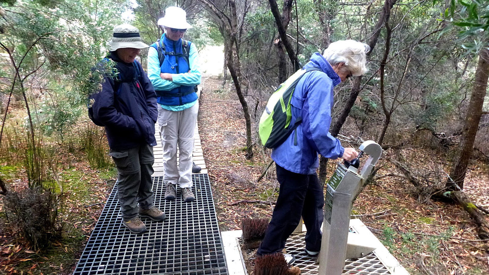
Ah well, we set off and meet our first obstacle, a coordination test
 |
| This apparatus sprays the bottom of your boot with a chemical that kills the dieback fungus |
You clean your boots on the brushes, insert one boot at a time in the covered spray area, and pull your boot back slowly as you push a handle forward that powers the spray.
I suspect the boot heels were treated and very little else. Perhaps two nozzles would provide better coverage and cut down wastage of the chemical by spraying both heel and sole of the boot.
On we go. Now, the start of the original track years ago was through a wet area, but that's all changed.
 |
| This raised track keeps you out of the mire |
It's a pleasant walk as we climb gently up through the bush.
I should mention that while signing the group in, we notice a sign on the information board saying that the tracks are closed on Tuesdays due to helicopter work delivering tools and materials to be used for track work.
Today is Tuesday and we've come a long way so that maybe a problem! But, as I said earlier, the car park is full to overflow with cars and minibuses and there isn't a crowd of disappointed walkers hanging around the sign, so on we go. I can report that there were a couple of low flying copters with dangling objects, but not near us at the present.
 |
| Easy walking |
It's not long before it's Morning Tea time and we find the first of seats provided for the weary bushwalker.
 |
| Morning Tea. The overflow from the above seat |
I could see a sign just past here and walked up to have a look. This is the junction with the Cape Raoul and Tunnel Bay tracks. Tea finished we head right onto the Tunnel Bay track, towards the lookout and eventually, Shipstern Bluff
We begin heading downhill now. In the past this was a bit of a slippery slide, now we have a gravel path and stone steps.
 |
| Sorry, but I still prefer no steps |
At least the bush is still the same, although higher than years ago.
Soon we reach another seat. This walking lark is pretty tiring.
 |
| Bush seat |
It's not long past the above feature we get the first glimpse of the water through the trees.
 |
| Now we can see the waters of Raoul Bay through the bush |
We reach a spot where we get our first look at Shipstern Bluff. We thought this was the lookout, but the official one is a bit farther on. As you can see, the weather is close to perfect.
 |
| Shipstern Bluff |
 |
| Hill next to lookout |
 |
| Ron pointing something of interest to Wayne and Bob |
I think I can see some people on the rocks below Shipstern Bluff, and indeed there are. I'm not sure what they are doing, or what those brown things are or what that white object on the track down is. Time will reveal all.
 |
| Mystery people below the bluff |
We find the official lookout and admire the view all over again.
 |
| Official Lookout. You can tell, it has railings |
We have quite a few metres to get down there, so we set off on a track that zig- zags down a steep face.
 |
| Zig- Zagging down |
We reach the bottom where the tea tree is in flower and follow the track to the turn off to the bluff. I remember it being like this before.
 |
| Flowering Tea Tree |
 |
| This track hasn't been interfered with yet |
 |
| Google created panorama |
 |
| We start descending towards Shipstern now |
Back to Google Earth, I could make out that there were lots of steps on the track leading down the stony beach. I would say it's been upgraded since that photo was taken. The steps now are not that old.
 |
| These are heading down, but somehow appear to be climbing |
 |
| The white object from the lookout photo. A bag of track materials delivered by chopper |
 |
| Raoul Bay |
 |
| Cape Raoul. That's a walk for the future |
 |
| Long shot of the lookout on the way down |
 |
| Shipstern Bluff. So named because it resembles a ship's stern. But not at this angle |
We reach bottom and the mystery of the four men is solved. They are Parks and Wildlife people, busy constructing some seats at the base of the bluff. More of them later.
After a chat, we climb around the base of the bluff to find a place for lunch.
 |
| Original track |
 |
| Rock shelf that was larger before the rock fall |
Wayne and Bob climb around to do some exploration.
On their return they report the rock shelf does extend on the other side, but we settle down here for lunch.
 |
| Bob and Wayne return |
 |
| Lunch |
It tries to rain, but it wasn't enough for the most nervous walker to bother with wet weather gear and soon stops.
 |
| The water, which was quite calm, is beginning to be a little rougher |
This is a popular area for surfers, google Shipstern Bluff and you'll find out how dangerous it is. No surfers today, however.
I said the Parks and Wildlife men were building seats down here, and the first one was finished. He couldn't get out of the way fast enough before we tried it out. His tools are still lying under the end of it.
The brown things I had seen from the lookout are replica surfboards and are attached to the top of a metal cage filled with rocks.
 |
| The U3A Kingborough Bushwalkers provide the first bums on seat! |
Of course, being a surfboard, it has to be tried and Peggy unleashes her inner surfer girl and provides a model.
 |
| Surfer Girl |
Off we go, bidding goodbye to the worker blokes, climbing back up the steps to head to Tunnel Bay.
It's not a great distance and we soon come in sight of the bay.
 |
| First sight of Tunnel Bay |
I've seen photos in other blogs of whale vertebrae at this site, but it seems to have disappeared. The photo below shows Ron and Wayne holding what, appears to be, bone from other parts of a whale.
We head across the rocky beach towards the features that give this place its name.
 |
| You can see the dark entrance of a tunnel |
 |
| A closer look |
 |
| Tunnel Bay |
 |
| Not everyone is captivated by a hole in the rock |
 |
| Ron goes exploring... |
 |
| ...and finds a cross tunnel in the rock |
 |
| Small rock pool below me |
The bush from here is pretty dense as you can see.
 |
| No tracks here |
There is another track that leads off and does appear on some older maps. It used to provide a circular walk back to the parking area, but runs into private property now. A road appears to lead from logging operations above, but doesn't go anywhere a walker would want to go.
We retrace our steps, heading back to the beginning.
On the way in to Tunnel Bay we passed some of the helicopter deliveries in the form of a large equipment and materials bag, tools, timber and a boot washing station. All to be installed.
 |
| I suppose our friends from Shipstern will be using these materials to install steps down and improve the track |
We reach the point where we begin the climb up the zig-zag track. At one point Bob spots the old wooden signs that have been taken down and left off in the bush.
 |
| Beautiful trees |
 |
| The track up |
 |
| We reach the lookout again and Geoff and Gail take a break |
Off we go again, up those bloody stone steps, past the sign for the walk to Cape Raoul, past the fancy seats and head down to the end.
 |
| Evidence of past logging |
 |
| Several cheerful and disgustingly healthy young people steamed past us |
I assume they had been on the Cape Raoul walk as we saw no group otherwise.
 |
| Part of the original track on the left |
We had 12 walkers and covered 13.68km in a leisurely 5.29hrs. A beautiful part of the world.
Click here to download GPX file


nice
ReplyDelete