Today Peter is taking us on a walk from the end of Taroona Crescent, along the beach beside the River Derwent and than up Truganini Track to the old signal station on Mt. Nelson.
Weather is cool and clear. Great for walking as we gather at Taroona Park and set off.
 |
| Leaving cars behind |
 |
| Looking south towards Alum Cliffs |
 |
| The route contains both sand walking and rock hopping |
 |
| There is a track above the beach that we will return on. Walking into the low winter sun |
Along the way, we pass Taroona High School which is just above the river. Some students are on the beach. Studying I presume as we pass through.
 |
| A local on the lookout for breakfast |
Peter shows us the sandstone bath someone has carved sometime in the past. Perhaps an unclean convict.
 |
| Might be a bit abrasive on the neither regions |
We continue rock hopping below cliffs that hide houses above.
 |
| Interesting geology |
 |
| Seems the rock artist whose handy work we encountered on the Alum Cliffs walk had been here |
A bit farther on, we found the whole family.
There was also a nicely decorated bush with shells for blooms.
Seeing all this handwork along the shore seems to indicate that life in Taroona is a bit slow.
We finally reach the point where we leave the beach to make our way up to the Channel Highway. A short distance to the north is the old quarry that marks the start of the Truganini Track.
 |
| Leaving the beach. I have no idea where that huge rock came from |
In the olden days the Channel Highway was the only way to reach Kingston and the Channel area. It was a long climb up the hill from Hobart and horses needed refreshment, particularly in hot weather.
So, a sandstone water trough was installed back in 1883.
 |
| Water for the horses |
 |
| Presumably the stonemason |
This is the old quarry which now is a small park complete with picnic table where we settle down for Morning Tea.
 |
| Walls of the old stone quarry |
Tea finished, we start on the track which runs beside Cartwright Creek for the first part.
 |
| Start of the track |
 |
| The first part along the creek isn't difficult |
We immediately lose what sunshine we had as the bush thickens and the track grows darker.
 |
| Cartwright Creek isn't exactly in full flow |
 |
| Looks a bit rough in that direction |
We soon turn away from the creek and begin the nice little climb.
It's a rough track with mud, rocks and wooden planks and logs placed across the track which act as rough steps in places, but I believe are there more to stop the track from washing out.
 |
| Looking back |
 |
| Looking across gives an indication of the slope |
 |
| The bush opens up as we climb... |
 |
| ...and we reach the Mt. Nelson Signal Station |
The building above was built in 1897 for the head signalman.
 |
| Signal Station flagstaff |
Built in 1811 to replace smoke signals signaling arrival and departure of ships in the port of Hobart, signals were originally passed with the use of flags.
By 1831 a semaphore (tall mast with 3 wooden arms) was used to send signals. This arrangement could deal with up to 666 codes.
Replacement with a 24 metre high six arm post allowed up to 900000 separate signals.
For more information - and it's very interesting -
CLICK HERE
It may be surprising to learn that the Signal Station continued in one form or another until 1979, 158 years.
This is where we will have lunch with views everywhere.
 |
| A comfortable lunch for some... |
 |
| ...a bit rougher for others |
 |
| Northern suburbs |
 |
| Someone - not me I hasten to say - likened these two gentlemen to the two old blokes on the Muppet Show |
Lunch finished, we begin to make our way back to the track and the trip down. But first, we visit the memorial to Truganini.
 |
| Memorial to Truganini |
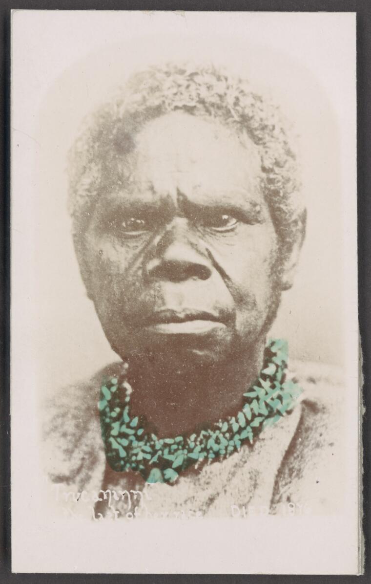 |
| Truganini |
Truganini c.1812 to 1876 is widely regarded as the last full-blood Tasmanian Aboriginal.
If you want more information, just look her up on the net as there is plenty there.
We regain the main track and start down.
 |
| Going down |
Walking down is quicker than climbing and we make our way back to the beach, but only for a short time as we will be returning on the track.
 |
| Up to the track |
The track isn't straight forward at this point and we have to make short walks past houses to pick it up again. One more point if interest is passed along the way.
 |
| Jas Batchelor, First Officer (Or Second depending on the source) of schooner 'Venus' |
Apparently died on board on the trip back from Calcutta.
We had 15 walkers and covered 11.99km in 5:07 hrs.
A great walk put together and led by Peter. He even arranged good weather!
Click here to download GPX file


No comments:
Post a Comment