Another beautiful day after some of the wild weather we've had. Good temperature for walking. Bob was our leader.
Starting off from the end of Lumeah Ave which runs off Kalang Ave, you begin the walk in open bush with a choice of tracks to follow. The walk continues on until we reach an open area that is also the start of our first hill. It's an entertaining slope, although some people had another description.
There's a muddy track that has had a tractor up in the near past and is full of ruts, at the top it joins a fire trail and provides a convenient log for Morning Tea.
Several of us felt a bit energetic (well, that's what we said) and started up the second climb before everyone had finished, which gave us the pleasure of watching them climb up while we waited at the top.
Then we went on a loop through forest that had been through a fairly recent fire and had a number of fallen trees to get over, before rejoining the fire trail.
 |
| Start of track. There's room to park cars and a turning circle at the beginning. |
 |
| Sally's lost already and is consulting her GPS. |
 |
| Easy walking |
 |
| About to get a bit harder |
 |
| Now we're feeling it! |
 |
| Doesn't look as steep as it felt. |
 |
| Early tea. Gordon on the left is struggling to get the cork out of his usual bottle of Champagne. |
 |
| I said I had found some more old fossils, but no one was amused! |
 |
| View from Morning Tea log |
 |
| Northern suburbs |
 |
| Second good climb |
 |
| Beginning of loop |
 |
| Legacy of bushfire |
After a short walk on the fire trail we came to a gate and started down and up to pick up a side trail. The only one with an actual name.
 |
| Down then up to catch a side track |
 |
| Another view of the first muddy climb in the distance. |
 |
| More obstacles. |
We continued down, coming to a paved road that could have been a drive to a house. Indeed, after a while going up it we came to signs of outbuildings and the sound of a dog. Fortunately we found the next track directly opposite the sign below and started down a steep, slippery slope. Story of my life.
 |
| We didn't go past. Honest! |
 |
| Down the slippery slope. |
We reached another track at the bottom near some signs of civilization, and turned back up hill. Nothing really attracted my photographic eye. This track brought us back to the paved road, but further down from where we originally joined it.
Taking a track on the other side brought us up to another hill top, where Bob gave us the choice of taking a side trip - down and back - or finding our own way back to the cars.
This was a very old track, with some new additions. I suppose it was during the recent high winds, someone had placed yellow/black tape across the track, with signs warning of falling trees. It wasn't windy now and the signs were lying on the track, so we carried on.
Under/over a couple of trees across the track, down to the bottom overlooking a new house. Then back up to decide where lunch was to be.
 |
| Bob found this interesting, colourful fungus. |
 |
| Can't say we weren't warned. |
 |
| Bracket fungus |
 |
| Old track |
 |
| Slightly younger walker |
 |
| Everyone at bottom of track, they made me walk down so the GPS track would be correct! |
|
|
Back at the top of the track, we decided to return to the cars, drive to John Turnbull park and have lunch. This was agreed to by everyone as a good idea.
So why does the next photo show us still in the bush and sitting on logs having lunch? Never mind, who needs a manicured park anyway?
 |
| Lunch in the bush |
 |
| Peter pointed this tiny orchid out to me. |
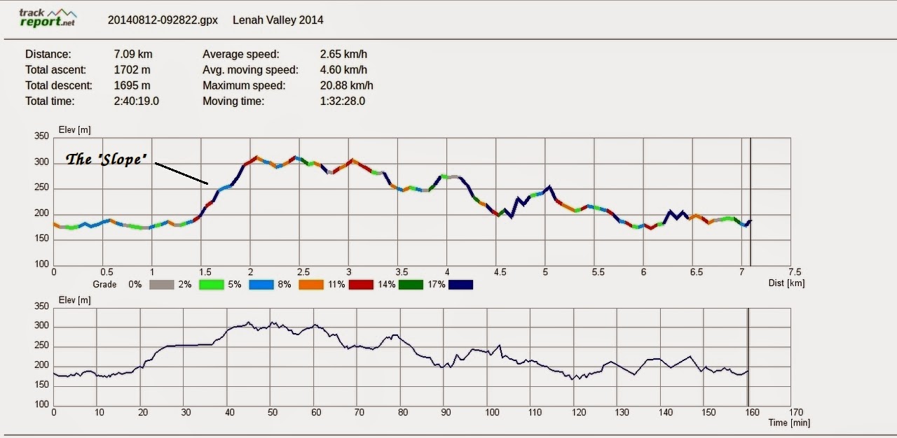
We had 9 walkers and covered 7.09km in 2:40 hours.
Sally pointed out to us that the Hobart Walking Club considers that every 100 metre climb is the equivalent of 1 km. So we can add a couple of kilometres to that total. Actually, every GPS seems to have its own idea about distance. I had my usual one that showed 6.18km in 2:40, but as it's new, I forgot to configure it to measure altitude, so I'm using the track from my phone. It's longer, anyway.
Also, the report slide shows the % of slope by the different colours in the graph, so you can see how steep the first climb was. It varies between 11% and 17%.
Click here to download GPX file


No comments:
Post a Comment