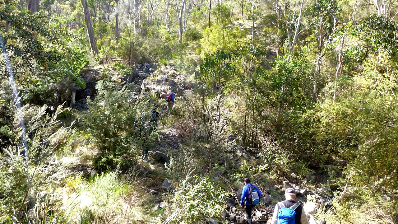
It's been a while since I used the 'snake', but one was seen today. It crossed rapidly in front of Bob's foot not long after we started. This is why we leave Bob at the front and why I usually bring up the rear.
Today we're walking the Lea and the back of Mt. Nelson. We had our doubts about the name of the walk - South Lea - but we did get quite close to a place called South Lea on the map, so we'll give it the benefit of the doubt.
The weather was perfect for the day. Not hot and a deep blue sky the camera had trouble reproducing. We park on Proctors Road, just off the north bound lane of the Southern Outlet and walk back, passing under the Outlet to find the start of the track at a metal gate. We did this same walk last year.
The track at first is an old, but well made road. Peter thinks it has convict connections. It's very overgrown and long trousers or gaiters are called for. Unless you're like me and don't mind leaving bits of DNA along the track.
 |
| Don't worry. Australian vegetation is soft and cuddly |
After a while we reach our turn off which takes us onto a less well made track. It's where a water mains was buried years ago which seems to be still in use. It also brings us to our first descent.
 |
| Going down on our first descent. Unfortunately, the walk description didn't mention the ascents, the first of which is ahead of us |
 |
| The old pipe crosses this almost dry creek |
I'd like to read a history and see a map of all the waterworks in the area. We come across the remains of various valves and other bits and pieces along the way.
It's up from here and a fairly steep climb it is. The bush, however is in bloom, distracting us as we climb.
 |
| First part of first climb |
 |
| A distraction |
 |
| We pass through a gate and keep going up |
 |
| Looking back, you can just see the organ pipes on Mt. Wellington in the centre through the gums |
 |
| Down again. As we begin to see the rolling hills, it's hard to believe we're 10 minutes from the centre of a capital city |
 |
| As we descend, we come across these concrete steps every so often, going down the slope |
They only extend part way across the track. Peter and I assume they are supporting the old cast iron pipe which is laid on this side of the old vehicle track.
 |
| Old sign marking pipe |
We reach the bottom and another very rocky creek crossing. Up we go again past some colourful blooms.
 |
| Down to a rocky crossing |
 |
| Looking back |
 |
| Bush colour |
 |
| The track opens out for a while |
 |
| Looking back at Mt. Wellington. You can get an idea of how blue and clear the sky was |
We pass some industrial archaeology and start down another track.
 |
| We're making our way to our Morning Tea stop |
We walk south, parallel to a dried creek bed to an open area next to an interesting installation.
 |
| Unexpected find in the bush |
 |
| The area around this building is surrounded by chain link fence |
 |
| Morning Tea and a comfortable rock for each of us |
The antennas, the fenced off area and the building are used for research into the ionosphere. There are, from memory, 5 other stations in Australia and they all can link to perform experimental exploration of the ionosphere, along with others overseas. It's located in this gully to exclude as much outside radio interference as possible.
 |
| Clematis in the bush |
Tea finished, we retrace our steps, pass our original track and continue on to find a crossing to an uphill track we knew from last year. Everything has grown since then so it's hard to find.
The track we're on is barely worthy of the name and looks like the last living beings that were on it were sheep and cattle in the wet winter.
 |
| I remember this from last time |
 |
| Cattle track looking back |
 |
| You don't want to wonder off into the bush |
 |
| You can disappear just as easily by keeping to the path |
This is a little used, narrow track with the added benefit of being up hill.
 |
| The track |
 |
| Getting our bearing |
 |
| Taking a breather |
 |
| Now, we're moving up a wider track |
We've turned right onto a wider track and are now climbing a gentle slope. In this particular area, the bush flowers to the left are white while to the right are yellow. Who knows why?
 |
| We pass a dam which appears on the map. It has a small island at this end covered with gums |
Soon we reach the top and a Transend Tower. Last year we had a tour of the Tas Maritime Radio installation which Transend allows to share the site. Have a look at the entry for The Lea (and Mt. Nelson) 2014 for details.
No tour this time, we continue on.
 |
| Shame about the wires, but you can see the Iron Pot Lighthouse in the distance |
 |
| We're making our way towards lunch |
We soon come to a gravel road turning left to follow it. In a short while we come to a gate with the signs facing away from us. Just after we make our way over and around the gate onto the public road, we have a typical Tasmanian moment.
A car comes along and who should be driving? It was Brian who gave us the tour of the radio facility last year, just about this time.
Brian will probably be very wary if he has to attend the facility this time next year!
 |
| We came from the other side of the sign |
From here we continue for a short distance turning onto Nelson Rd. and heading for the oval and lunch.
The facilities at the oval are quite good and we found a table that could accommodate all of us.
 |
| Lunch at the long table |
 |
| Street view |
While at lunch we were entertained by children playing on all the equipment that has been installed in the park. By children I don't mean toddlers and primary age. No, these were 16 to 18 y.o. teenagers. First we had the male group, then a little while later as we were leaving, the girls arrived. No doubt they all came from Hobart College just down the road. Good thing the new play equipment was robustly made, as it took a beating.
We walked down Nelson Rd., passing the shop, then turning left to pick up a walking track. This will lead us down and join our convict road we started out on, returning us to our cars.
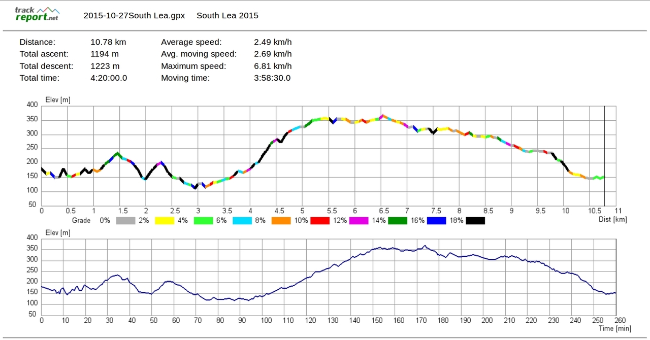
We had 8 walkers and covered 10.78km in 3:58hrs.
It was a beautiful day and good walking. I think some of us feel this should be graded G3 and the description of steep descents removed as there are worse on other walks.
Click here to download GPX file


No comments:
Post a Comment