Well, it finally happened, we did the Mt. Direction walk that's been postponed twice. Whatever sacrifices Tas made to the weather god(s) finally worked and we had a perfect day.
We started out at Risdon Brook Dam, across the dam and off onto a new route. Tas is our leader.
 |
| Quite a few cars and at least one school group at the dam |
 |
| Risdon Brook Dam |
As we crossed the dam, we were closely followed by a couple of young women who continued behind us when we turned off. After interrogation they said they were going to Mt. Direction also, so continued along with us for a while.
 |
| We've turned off the track around the dam and are heading towards the power lines |
 |
| Bit of cloud on Mt. Wellington |
 |
| This part is on a wide gravel road |
 |
| Heading up |
 |
| Surrounded by hills |
The weather is clear and it only takes a short stint up a slope to warm everyone up, so we stop to strip excess clothing.
 |
| Strip stop |
We're off again and on a more scrubby track for a while.
 |
| Looking back |
Soon we come to another turnoff point, Tas is following an article by John Cannon that appeared in the Mercury with directions.
The two young ladies are also with us, but not for long. This is also about where we lost Bob, who kept on going on the route he was familiar with, the girls following him. Bob's probably used to it!
Off the rest of us go, over a large fallen gum tree.
 |
| Into the unknown |
 |
| The two girls are next Adie who's in the shorts |
 |
| Looking back you can see a bit of the Derwent |
 |
| Heading up |
We're climbing up an old track next to a equally old fence. It's a steep climb and you have to admire the work needed to put a fence up on this slope.
As we climb the view gets better behind us.
 |
| The view's a bit better and you can just make out the Tasman Bridge in the centre |
 |
| Taking a breather and admiring the view |
 |
| There's still plenty of 'up' left to do |
 |
| This gives an idea of the slope |
 |
| Now it becomes an individual scramble |
 |
| There's more loose rock as we climb |
 |
| Zig Zaging is required to find a safe way up |
It's getting close to Morning Tea and an undercurrent begins to develop as time marches on. Again I was requested to record the time for any further action to be taken. Soon however, we find a couple of nicely placed logs and settle down for a break.
 |
| Six minutes late. An uprising is close! |
 |
| Warfare avoided, we take a well earned break |
As we rest, voices come from above. No, not that kind of moment, but a school group that left before us is swarming down the hill. One of our group asks the teacher (they didn't have teachers like that when I was in school) what school they were from and she replied "Campania". This being Tasmania there were immediate connections between members of our group and Campania School, including myself as Val had taught there after leaving Uni.
 |
| The kids continued on down the hill... |
 |
| ... while we finished and continued up |
We turned off shortly and started up to the first summit, which was surmounted by a small stone cairn.
 |
| Passing view of Gunners Quoin |
 |
| Off the old track and up |
 |
| We're getting near the top of the first summit |
 |
| Fresh example of schoolboy humor |
 |
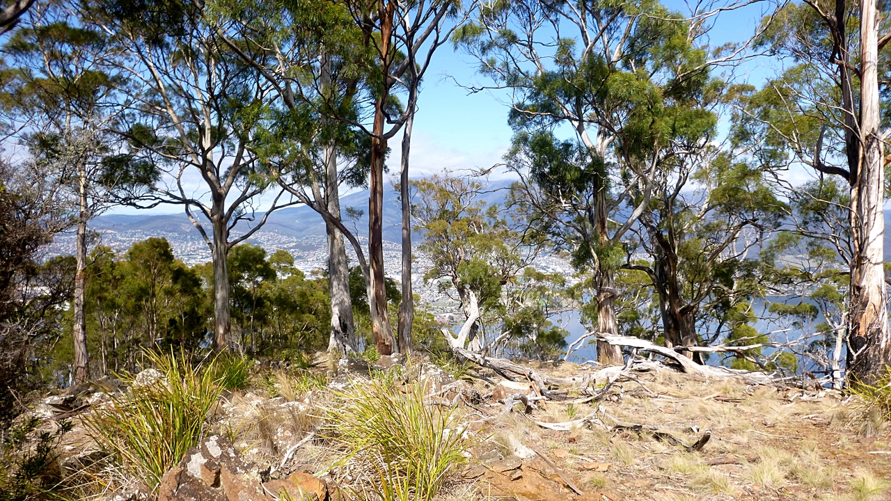
| The views would be better without all the pesky gums in the way. Where's Paul Harriss when you need him? |
 |
| Difficult to make out, but that's our next destination |
 |
| Our work here is done, so we move off |
We have a look around and get ready to start off again for the final
summit.
There was a brief sighting of Bob in the distance, but then we lost him again.
 |
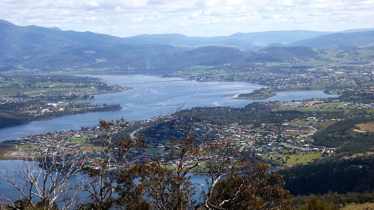
| View of the Derwent looking north |
There are a number of photos of this view as Adie is looking for a good one to paint a landscape from.
The track is quite easy as there's a communication installation
on top so access is required for the techs.
 |
| There was much discussion re the red feature in the left centre. |
|
|
 |
| That splodge of red is what we're talking about. |
Some suggested it was the red awnings that council forced a building owner in Murray St. to remove. Surely a council that ignores it's own planning regulations and approves a building three times the allowed height wouldn't do that!
Google Earth has solved the mystery. It's a large area of shade cloth on a property called Fairfields just off Old Beach Rd.
 |
| From Google Earth. Splodge explained |
We have a look around the large stone cairn and the views are much better here.
 |
| I always wonder who built this and how long it took |
Eventually, we start back down and our route will be on the track everyone usually uses.
 |
| You can just see the Bridgewater Bridge in the distance |
I remember walking up some 20 years ago or so, and it was a bit different then. The road now is loose stone and makes for some interesting moments on the way down.
 |
| Heading down the slippery slope |
 |
| I personally discovered some new muscles the next day after walking down here |
 |
| Yep, Gunners Quoin again |
 |
| Adie goes off track. Tas didn't see. |
 |
| Risdon Brook is in sight |
We reach the road around the dam and find a good spot for lunch. It even has a bench!
 |
| A pleasant spot for lunch |
 |
| I mentioned the difficulty of multitasking in the past. You can either have a photo of me looking happy without Peter or one of both Peter and myself. |
Lunch is always an interesting time. Some people pull out plastic containers and plastic cutlery to consume some sort of salad or cold pasta. Others may have choices of fruit or sandwiches. I had tuna salad. In the photo below, Tas and Ron are having the latest of paleo diets. It looks interesting but creates a mess.
 |
| Tas and Ron enjoying their paleo diet lunch |
 |
| I suppose our ancestors didn't pickup after themselves either |
After lunch we walked back to the cars where we found Bob waiting. It was a good walk with a strong up hill element. I warn you Tas has another route in mind for the future.
We had 12 walkers and covered 7.48km in 3:33hrs.
Click here to download GPX file


No comments:
Post a Comment