NEWS
You all know Bob of wee, tiny, small hill fame. He's the one always willing to drag us up the nearest slope. Well, Bob wasn't with us last week on our Waterfall Bay walk. He was recovering from running the Cadbury Half Marathon on the Sunday.
Bob came 2nd in his class and 256th out of 745 entries plus he did it in 1:50:11.
Not bad for an old bugger!
******
Today Tas is leading us along the Alum Cliffs in Kingston. They're alum in name only not composition.
The light in many of the photos may seem strange and distant objects are hard to view. This is because Tasmania has 80+ bushfires at the moment, mainly in the north and northwest, but the smoke has covered much of the island. No fires in the south. Yet.
 |
| We gather in the Beach St. car park and head for Kingston Beach |
 |
| It's a bit early, I suppose that's why it appears empty. |
There are a few people around, mostly walking dogs as the northern end of the beach is a dog exercise area.
Over Browns River to start the track which winds up hill.
 |
| Looking out to the Derwent River |
 |
| Looking upstream, the Wellington range is mostly behind smoke |
To make sure you enjoy the walk, Health & Safety have put up a welcome sign.
 |
| Enjoy |
They should have included: DO NOT WALK BACKWARDS
NO DANCING
WALKING WITH EYES CLOSED IS PROHIBITED
CLEAN UNDERWEAR MUST BE WORN
I'm sure you can think of other necessary warnings.
Forewarned is forearmed as they say, and we just avoided a fallen rock.
 |
| We narrowly missed that one |
 |
| I hope stopping and looking backwards is o.k. |
 |
| Looking down at the mouth of Browns River |
We pass through a burnt out area near some houses which I suspect is the result of a controlled burn.
 |
| Burnt bush |

 |
| We come across these shelters fairly often in our walks. |
 |
| Interesting three pronged gum shedding its bark |
Now it's easy walking.
 |
| We're past the burnt area and it's greener now |
 |
| Very dry creek bed |
 |
| Bob's at the front waiting for instructions from Tas |
I avoided taking photos of people eating and drinking as you can see that in the blog from last year. Instead I took a couple of photos of the cliffs.
 |
| Alum Cliffs |


 |
| Bulk carrier at anchor, shrouded in smoke |
 |
| Why the Australian bush burns so readily |
 |
| Turning off the main track |

 |
| I know Richard doesn't like his photo taken, so I timed this one just right |

The track takes us to a short gravel section leading to Wootten Drive. This is where some of us had trouble.
While the rest of you swan off into the distance, Ron, Richard and myself are well back. As we were nearing Wootten Drive, Richard heard someone calling which turned out to be a woman who lived in the nearby house .
She inquired who we were and where we were from, which we told her. Seems that short gravel section we've used for the past five years or so is private. We suggested she should contact the council as there is no indication at the start of the track that it enters private land.
It was all amicable, but she obviously didn't want us walking there. I did wonder afterwards who built the duck-boarding over the drainage ditch from the end of the track to the gravel road. She did say that the track crossed private land and the owner of THAT land was happy for walkers to use it.
She is correct about the gravel road, but misinformed about ownership of the land we had walked across.
The map below is taken from the List Tasmania map site with our GPS track overlaid - the thin blue line. My question is: What is a Casement? There appears to be a way from the end of our track to Wootten Drive that doesn't pass over private property.
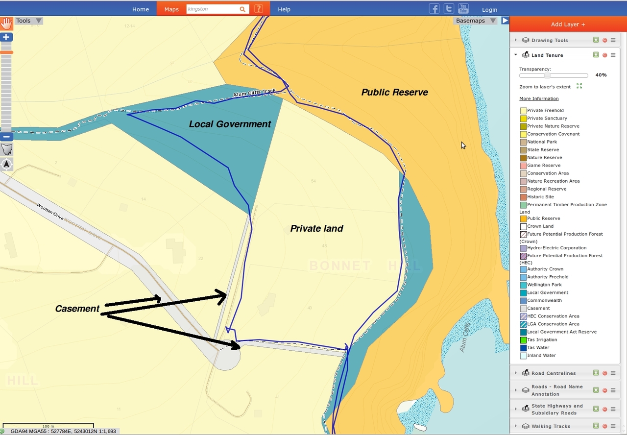
Wootten Drive, the way we walked down to the Alum Cliffs track and the little grey strip along side the private gravel road all have the same Tenure Class as 'casement' and the same Tenure Number, 3676. It would be nice if there was a legal way to walk this loop.
Back to business. We return to the Alum Cliffs track and walk back towards Kingston for a short while before turning off into the unknown. Bob's taking us down the original track, one he and Ron used to run.
It leads down towards the water, then climbs up back to the new track and is a worthwhile diversion.

 |
| It's a scramble in places |

 |
| Looking south. If you look carefully at the rock left of centre, you'll see a gentleman fishing |
 |
| We climb up to an area with good views which would be great on a clear day |
 |
| Bob volunteered to take my photo. There's a large drop behind me and I ignored Bob's requests to "Back up just a little more" |
 |
| Remains of old steps |
As we started up, a group of teenagers came down carrying packs which was good to see.
We return to Kingston Beach and make our way to Alex's veranda for lunch.
 |
| Mouth of Browns River |
There were actually a lot more people on the beach in in the pools then appears from the above photo.
 |
| The view from the verandah |

 |
| Perfect spot for lunch |
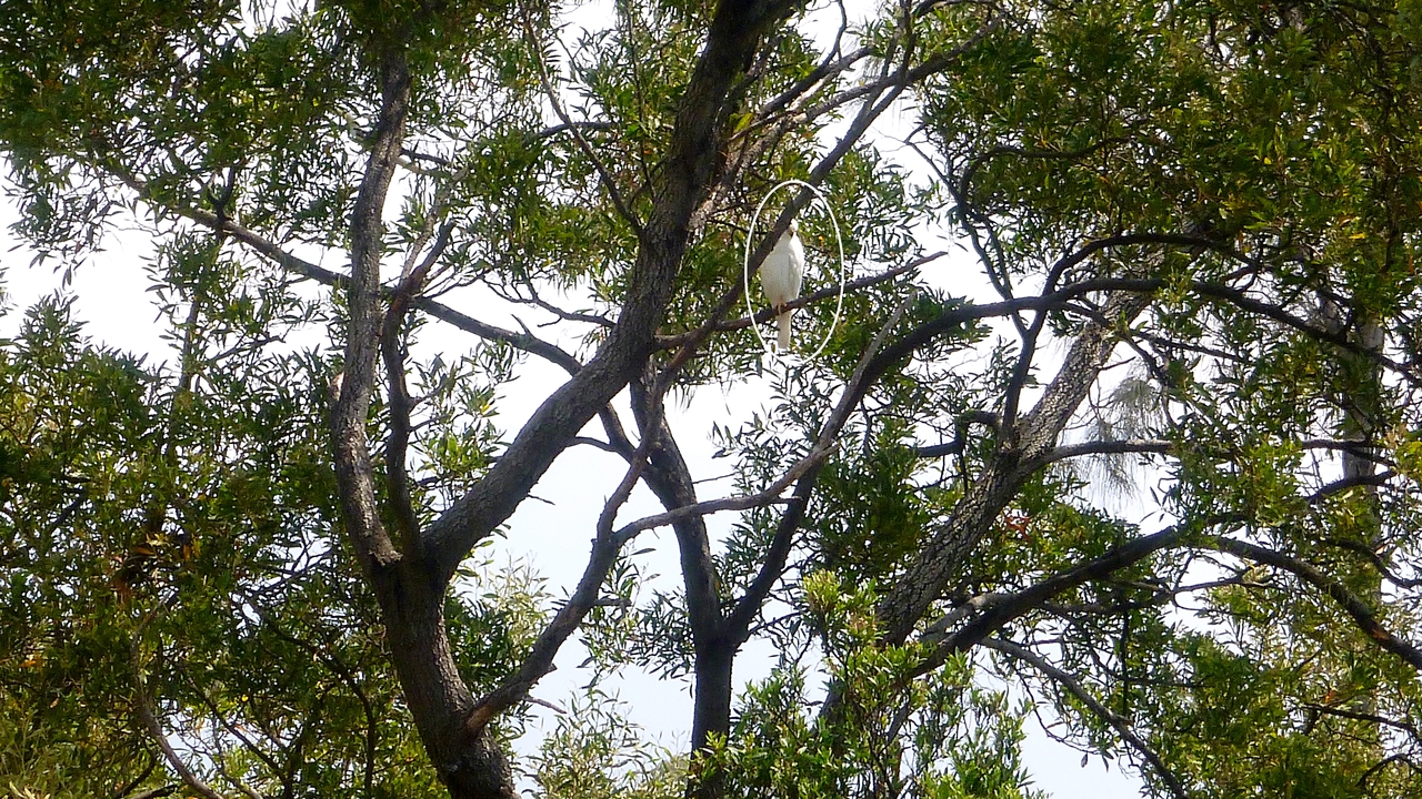 |
| Grey Goshawk, often called the White Goshawk |

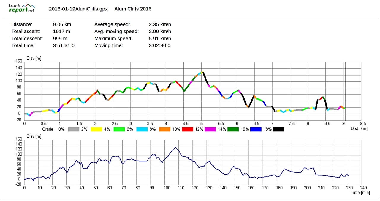
We had 14 walkers and covered 9.06km in 3:51hrs. Despite the smoke it was a good walk with a great ending. Thanks to Alex for her hospitality and company.
Click here to download GPX file
Finally, if anyone is interested in the new Three Capes Track, have a look at Hiking South East Tasmania. You can find it in the list GOOD SITES TO FOLLOW and it's very interesting.


No comments:
Post a Comment