Today turned out to be a big one. We're heading towards New Norfolk to climb Mt. Dromedary. The weather is fine with warm, clear conditions predicted.
I was going to get a photo on the way back of Mt. Dromedary, but circumstances decreed I didn't. So I've used this photo from Google Earth which will give you an idea of where we climbed.
At our meeting point in Denison St. Kingston, someone mentions that the Pandani Walking Club is also heading that way. I hope not too many as parking is limited.
We regroup in New Norfolk before heading to a familiar starting point in Braslins Road. This is also the start for the walk to Platform Peak.
Pandani have arrived before us.
Even if you think you'll be the only walkers, perhaps you should consider not taking up most of the limited parking just in case you're wrong.
Getting parked we gear up to set off up the gated road.
 |
| Heading up the gated portion of Braslins Road |
 |
| The temperature was 13C when we parked and it doesn't take long to get warmed up and lose some of the extra clothing |
I soon spotted the first wildlife that managed to avoid all the feet ahead of me.
In trying to identify what this is I came across a very interesting website devoted to Tasmanian Insects.
Click Here to visit it.
This appears to be a member of the family of Stoneflies.
Back to going up the road.
 |
| Looking back |
After a while we reach the junction of tracks, one to Platform Peak and one to Mt. Dromedary.
It's been a while since we've been up here, and someone has put handy signs on the tracks.
 |
| This marks the track we want |
 |
| A pleasant start on a new (to most of us) track |
 |
| This area has been logged in the past |
 |
| The track has many faces |
|
|
|
|
We pass several varieties of interesting fungus on the way.
 |
| Quite a good size clump |
We reach another junction and turn left to find a spot for Morning Tea.
 |
| Morning Tea. Here's Bob... |
 |
| ...and around a corner the rest |
Actually, Bob wasn't really left on his own, there were several others just out of camera view.
 |
| We're starting to get a view of our objective |
Tea finished we backtrack to take another track. This has also been sign-posted by someone.
We could have followed the track we had Morning Tea on and reached the same spot, perhaps another time.
 |
| A buzzy. This will attach itself to you very easily with those spikes |
|
|
This track winds through new growth and over a couple of wet spots taking us to the start of a track leading up.
 |
| Young growth |
 |
| Clean, green marker at start of track up |
 |
| It's a foot pad now |
 |
| Modern plastic marker |
 |
| It's a quite pleasant, level walk at the moment |
Soon however, we're are going to have to go up.
 |
| Going up |
There are a number of logs of various size to clamber over or, in some cases, under.
We do start to get some views between the trees when we stop for a breather.
It's not long before we begin climbing up loose, wet and mossy rocks which add to the adventure.
Bob finds a lunch spot which provides a fallen log and a number of comfortable (?) rocks to sit on.
 |
| Lunch on the rocks. Bit different from lunch on the rocks in Sydney |
 |
| Lunch finished, off we go again |
The track zig zags up and passes through a small section of rain forest which is completely different from a few metres above and below.
Walkers ahead alert me to some colour next to and on the track.
 |
| Nice to have a bit of colour |
Farther on Wayne points out this large group of fungus shown below. It stretches into the bush on both sides of the track and has lifted up the surface.
 |
| The track |
We reach a spot where Bob asks us to wait while he explores a side track which takes him awhile. On return he tells us about a great lookout we can visit on our way back down.
On we go, still climbing until we suddenly reach the top and the trig marker.
 |
| My first view |
 |
| I crawl around the bottom of the trig point to get a photo. It takes two to get everyone on top |
 |
| A local emerges from the rock pile supporting the trig point to see what all the noise is about |
We start back down and some of the party have streaked ahead when we reach the point to turn off for the other lookout. They elect to wait for us while we go have a look.
Bob reckons the view is even better than at the peak, and I think he's right. There is a bit of a scramble but plenty of room on top to have a look.
 |
| You get a view of the River Derwent towards Bridgewater & Hobart |
 |
| Viewed in a larger size you can see the Bridgewater Bridge in the foreground and the Bowen Bridge in the distance |
 |
| Photo by Bob |
 |
| Photo by Bob |
 |
| Photo by Bob |
Now we start the trek down.
 |
| Looking back at the top. You can make out the trig marker |
 |
| Going down |
We make our way down retracing out steps. We've been quite a while and mobile phones come out to let families know we're going to be a bit later than normal.
We've passed the junction of the Platform Peak and Mt. Dromedary tracks when about a dozen rain drops which amount to nothing.
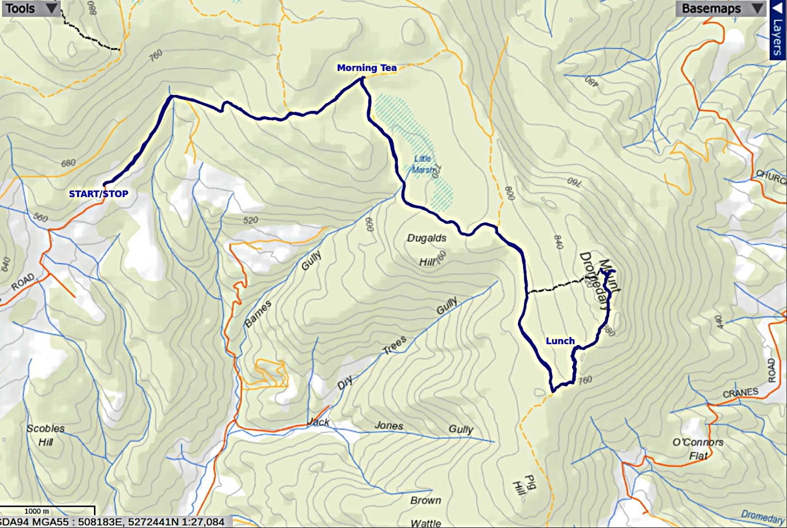
We had 12 walkers and covered 16.76km in 7.09hrs. We had some discussion as to whether this was our latest walk finish or not. There was one back in 2015 involving the Snake Plains track which took 7.07hrs and covered 18.8km so we'll call it a tie. The moving times are more enlightening, Mt. Dromedary was 5:55 hrs and the Snake Plains adventure had a moving time of 6:12 hrs.
Perfect day for the walk and something both I and many others had wanted to do for a long time. Thanks to Bob for all the exploring and accessing of the tracks making it possible for us to do it.
For the record, I reached home at 1910 (7:10p.m.).
Click here to download GPX file


No comments:
Post a Comment