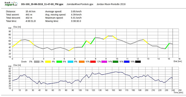
Today is a rare grade one walk along the Jordan River and around Pontville with a bit of Brighton included.
The weather isn't promising, but not bad enough to cancel so we set off, heading north.
On arrival we park behind the Memorial Hall, next to the football ground. It's overcast, but not too bad as we head off.
For a short but interesting history of Pontville,
CLICK HERE
 |
| Leaving the cars and heading back to the main road |
 |
| St. Matthew's Church |
 |
| Nice wide path - if you like concrete |
We're heading south past the old Brighton Army Camp or Brighton Barracks, established around 1826 and used for training Australian Soldiers for both World Wars, the Korean War and the Vietnam War among others. Sold to a mainland developer by the state government of the day back in 2003 - and it wasn't a popular decision.
 |
| Entrance to Brighton Barracks today |
On we go, still heading south. Just past the above entrance we turn left into Jordan Downs Drive, heading towards River Court and a right hand turn.
 |
| Jordan Downs Drive |
At the end of River Court is a footpath leading to Jubilee Avenue and suburbia.
 |
| The path |
 |
| Suburbia ahead |
We head left, towards the Jordan River
 |
| That hill is on the other side of the Jordan River |
Looking at the map, that is the start of the Meehan Range of hills which run down the eastern shore of the River Derwent, and contains a number of our walks.
We begin to see some of the older homes mixed in with the new.
 |
| Older homes. One looks likes it may have been a shop |
Right next to the river, and at the start of the river walk is the cottage pictured below. I remember it as mostly a ruin many years ago.
 |
| Start of the river walk |
 |
| The last time we walked here, the river was dry |
It's an easy walk, and except for a short distance at the beginning and end, is hard surface.
 |
| Rear of another old house |
 |
| Renovations have started, the satellite dish is installed |
 |
| Every flowering plant thinks Spring is here |
 |
| Looking back |
 |
| Plenty of weather about |
 |
| Morning Tea |
This little shelter is at the other end of the walk, near Ford Road.
Tea finished, we move on. As we reach the road to crossover and turn left, a number of cars cause us to wait. This attracts the local birdlife who are obviously used to getting fed, causing a mini traffic jam.
When they realize we're not to give them anything, the road clears and the cars continue on their way.
 |
| Northern end of the walking track |
 |
| Greedy, unfed ducks and geese |
I don't think they'll starve. Ford Road used to be a ford where you drove through the river, now it's a low bridge.
On we go, heading towards Brighton Road where we turn right for a short distance, cross over and start on the bike track.
 |
| Another older home, built from local stone |
 |
| Pontville with it's colonial buildings and convict built bridge |
 |
| We turn off here to follow the bike track |
 |
| This used to be ruin, not sure what's happening with it now |
It's on the site of the original quarry where the stone for the bridge and many buildings came from.
 |
| The track with the river below on our right |
 |
| Colonial houses |
 |
| Jordan River with introduced willow trees |
 |
| Take two photos and they disappear in the distance |
 |
| Steep, rocky hillside opposide |
 |
| Localized weather event in the distance |
 |
| It took me about 1km to catchup |
 |
| Older homestead in the distance, below the hills |
We reach the end of the track which takes us up to Hartley Court.
 |
| The track ends just up the hill |
 |
| Mildly interested locals |
We've some sprinkles of rain and the cloud cover is looking ominous as we make our way towards a lunch spot.
Bob takes us on a large loop of the outer streets before entering Racecourse Road and turning off into a public area. Here we make our way around the outside of the track, heading for the stands on the opposite side.
 |
| Brighton Racecourse |
 |
| Lunch |
We find convenient seating and settle down for lunch. Unfortunately, the weather has other ideas and it begins to rain. Enough so that even I pull out some wet weather gear and we move back under the overhang of the grandstand roof.
After lunch we begin to make our way back to the cars, but by a convoluted route to get the kilometres up. Still raining, so I don't bother with any more photos. Particularly as some of the route back is on the same riverside path.
We had 12 walkers and covered 15.44km in 4.0hrs. I hit a personal best of almost 6kmh in catching up after taking photos.
A good walk with a lack of hills which is made up by fast walking and a good distance travelled.
Click here to download GPX file


No comments:
Post a Comment