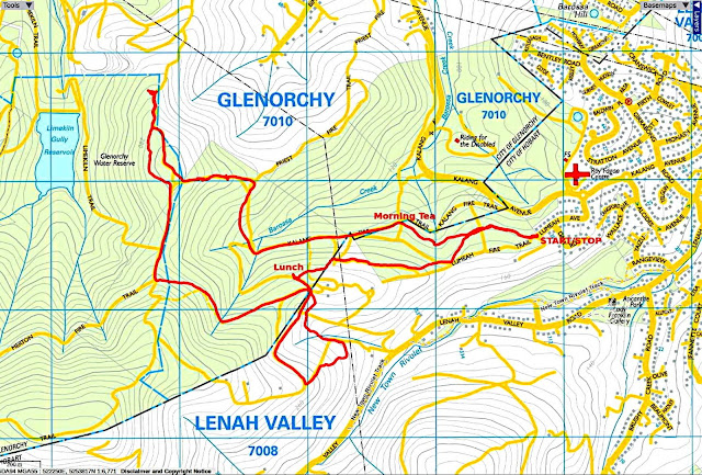
Today we're walking at Lenah Valley from the end of Lumeah Avenue for the first time since 2014. Parking at the end of the avenue, we enter the Lumeah Fire trail on a cool but clear day.
 |
| Not a large group |
This is a time of year many of our members are away.
 |
| View from the beginning of the track |
Looking over Moonah and beyond.
 |
| Easy walking, but I know what's coming |
We reach a spot where we leave the track and begin to climb and it gets steeper as we get higher. Finally we reach another fire trail, walking up a short distance for an early Morning Tea.
 |
| We started up from down in the tree line below |
 |
| You wouldn't know we're not far from houses |
 |
| View looking back |
 |
| Morning Tea |
This area was under water eons ago and you can find many fossil impressions in the rocks. So, while the others enjoy their break, I start up the next climb, checking out the rocks along the way look for old fossils.
 |
| First rock with shell impressions I found |
Farther up I see this large rock beside the track. It shows a cross section of the geology of this area.
 |
| Large rock showing the layers |
 |
| Looking down the track |
 |
| There's still a bit of a climb |

I continue to climb, looking for some more old fossils.
 |
| Not them... |
 |
| ...but these and the ones in the photo below |
The rest of the group arrive and we continue up to a track junction, turning right and heading towards a spot overlooking Tolosa Park. Bob wants to check out something.
We walk back up the hill for a short distance, turning off at a spot Bob took note of earlier. The terrain here is very barren and rocky. Poor soil makes it difficult for anything to grow, plus it had a bushfire through here a couple of years ago.
We find the Priest Fire Trail, turning right to enter Wellington Park.
We follow the fire trail to a point where a vehicle gate near a house takes us onto a road. Walking down this takes us to another unmarked road where we head up.
 |
| Unmarked roads |
These roads are private roads and you enter off Lenah Valley road. Somewhere up here we turnoff onto an unmarked track, making a loop that takes us back to the house and gate we passed before.
There is new wire fencing installed around the reserve areas. In the example above the pink oval shows a marking tape hanging from the bottom wire. It's at least two metres above the ground!
 |
| Turning off the road just below a house, we head down |
 |
| Not a trail but where a phone cable has been installed |
When we reach the gate we came through earlier, we walk down an unmarked fire trail for lunch.
 |
| Heading for lunch |
 |
| Looking back |
 |
| Lunch |
After lunch we walk back a short distance to follow Bob down a little track.
 |
| Unmarked track leading down |
We gradually make our way back to the cars.
We had seven walkers and covered 6.07km in 3hrs. A short walk, but a couple of steep climbs and very interesting. Bob did his best to make it longer.
The lack of some track and road names made it very confusing as to where we walked.
Click Here to see animated track.
Click here to download GPX file


No comments:
Post a Comment