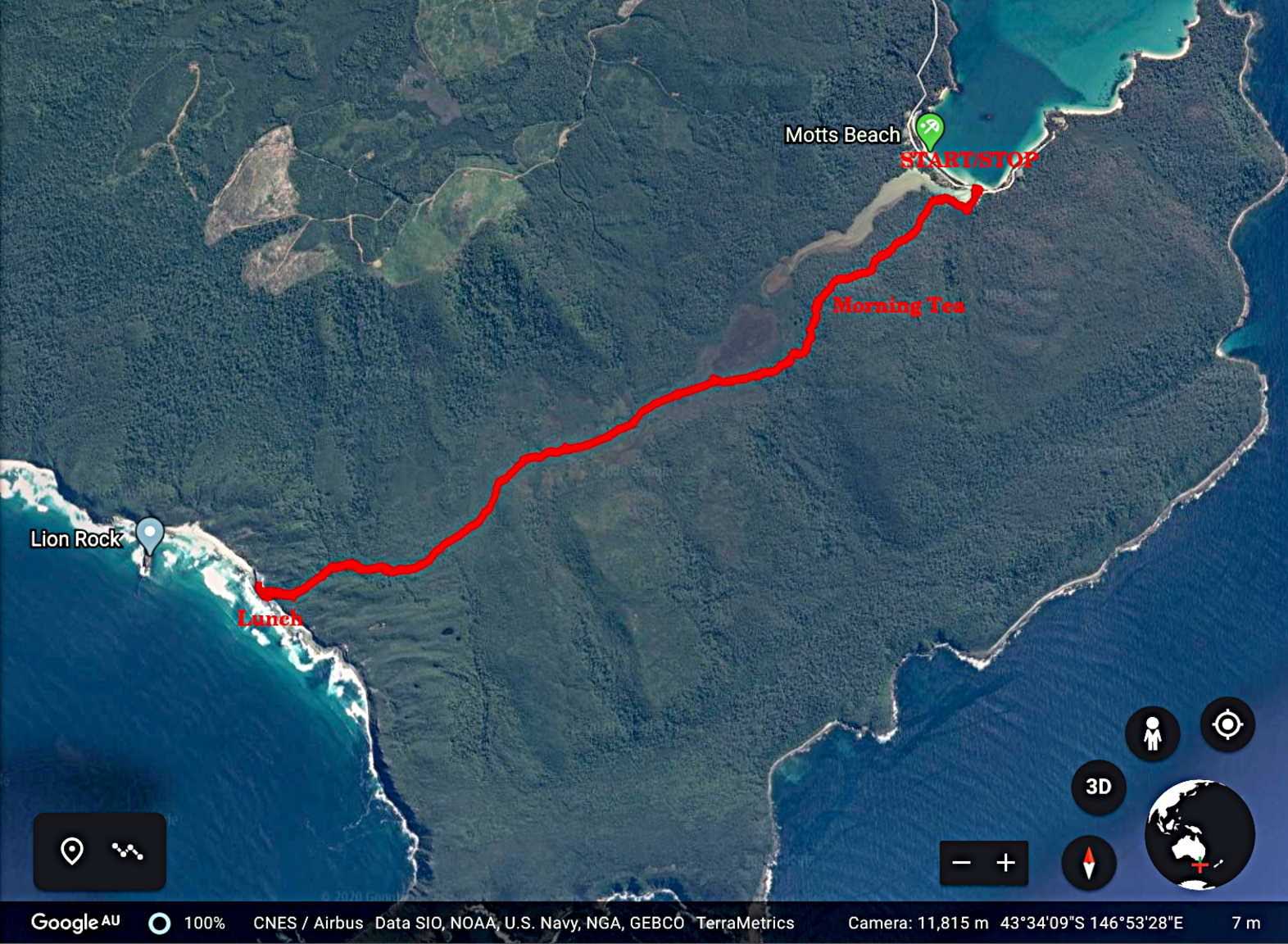
Today we're heading south to Cockle Creek, roughly 2 hours drive from Kingston. Our walking destination is South Cape Bay.
It's an interesting drive mainly on paved roads that, unfortunately for mainland drivers, have some curves. The weather is overcast, but forecast to be 25C later in the day. However when we arrive at our starting point it's very pleasant as we dismount, stretch and have a look around. It's been years since I've been down here and there have been few changes.
 |
| Mouth of Cockle Creek at Rocky Bay |
 |
| A couple of shacks near the parking area |
A Tasmanian shack is a holiday home, and they could be larger and newer than the two above and still be called a shack. Sadly, this is disappearing. For an interesting short article about the unique shack culture of Tasmania,
CLICK HERE
 |
| Interesting signpost |
 |
| I've rotated it to save your neck |
 |
| People walking up the south beach of Rocky Bay |
Cockle Creek was first visited by the French explorer Bruni D'Entrecasteaux and his two ships in 1792 and 1793. In 2003 the remains of a garden planted by the French was found. In the 1830's whaling and sealing took place with several whaling stations. With his usual skill, killing males, females and calves, mankind wiped out the whale population and the stations closed.
Coal was discovered but it wasn't long before it ran out.
Timber was next, the Huon Pine followed by Stringybark eucalyptus.
The last timber mill was run by the Heather family until 1947, milling locally cut Stringybark. I found an article and a couple of photos which I found interesting. People were tough in those days!
 |
| Remains of the Heather family saw mill |
 |
| Notice the organically grown rails |
 |
| Fascinating life |
It's a World Heritage Area now.
Well, we'd better set off.
 |
| Very start of the track |
 |
| This area is somewhat damp |
We come to a shelter with registration book and next a boot washing station that actually works!
 |
| Bob now has clean boots |
 |
| It's all to prevent a certain fungus getting hold in our forests |
It's called Chytrid and has killed entire frog populations in other parts of the world and has appeared in some places in Tassie.
The track becomes an easy to walk, stony path with no great climbs, just a gentle up and down for the first part.
 |
| Looking back |
 |
| Morning Tea |
I didn't mention that the car park had several motor-homes, campers etc in it. Most seemed to be from Queensland. Because of the drive down, Morning Tea was late and we set up here for our break.
We had several groups of walkers pass us including a group of bearded young men who were in the motor-home and evidently from Poland.
Hope they managed to get out of Tassie and Australia before the lock down because of the virus.
On we go winding up and down before coming to duck-boarding crossing the Blow Hole Valley.
 |
| Going down |
 |
| One of the old giants left behind |
 |
| Blow Hole Valley |
 |
| The duck-boarding |
This continues over swamp land and water hazards for quite a way until we reach a raised area, like an island.
 |
| Off the boards and up to a quite pleasant area |
 |
| Quite a deep depression with water coming out at the bottom |
 |
| The water disappears just about here |
We cross a foot bridge to continue on.
 |
| Pleasant walking... |
 |
| ...but not very green on our left |
 |
| There was this small water fall |
I think this is still Cockle Creek judging from the map.
Suddenly, things change and conditions get much tougher.
 |
| Life wasn't meant to be easy |
There were actually a couple of fallen trees to navigate. We're getting close to the coast as I can hear surf in the distance.
It's not long before we exit the bush onto an area of bare rock overlook South Cape Bay with some earlier walkers in view.
Certainly some of the rock is a form of sandstone, but I don't know about the rest of it.
 |
| Arrival at South Cape Bay |
 |
| Looking north at Lion Rock |
 |
| Looking south |
 |
| Well, no. Someone has put this sign here and someone else has tried to correct it |
Cockle Creek where we parked is the southern most place in Australia you can drive to. South Cape Bay is not the southern most point of Australia. You're going to have to work a bit harder if you want to visit that spot. Just look at the map below.
As far as I can see from maps, there is no track there. The next stop from the end of South East Cape is Antarctica.
We have a look around before Peter takes us to our lunch spot.
 |
| We didn't bother going to the beach. There were already three people on it and was too crowded for us |
 |
Ron spotted these
succulents on a rock. They were also growing on the ground in spots |
 |
| Looking north |
 |
| Lion Rock |
 |
| I think that's South Cape |
If you look carefully, you can see an island just left of centre. I think this is Maatsuyker Island.
 |
| Looking south |
 |
| That's the most southern point in Australia, South East Cape with the Three Hillocks |
Peter leads us up into the bush to a couple of clear areas for lunch. The temperature has risen, but it's still very pleasant.
Soon we start on our way back and almost immediately things look different.
 |
| We didn't notice these windswept trees on the way in |
 |
| Back to the duck-boards |
This is a very good and not difficult walk. It's part of the South Coast Track. This track isn't for beginners as it's 85km long without any amenities. To reach the start at Melaleuca you have to fly in and be prepared for a 6-8 day hike.
Have a look if you want to daydream.
CLICK HERE
We had 7 walkers and covered 16.31km in 5:18hrs. A great walk led by Peter. Thanks for a great day in the bush.
You don't need to download a GPX track for this one.


No comments:
Post a Comment