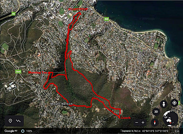
Today Marilyn is taking us from Lambert Ave in Sandy Bay and at sea level up to the Signal Station at the top of Mt. Nelson at around 352 metres above sea level.
The day is perfect for walking as we set off from Lambert Ave, along side the Lambert Rivulet.
 |
| Nice wide track |
It's not long before we begin to warm up and Marilyn offers us a chance to remove (some) clothing.
 |
| Strip Stop |
 |
| Looking up the River Derwent |
On we go, still climbing. Areas vary from open bush to very rocky in spots.
 |
| Looking back |
 |
| We reach the back fences of houses along the boundary and follow them towards the top |
 |
| Looking downhill |
 |
| Morning Tea |
The house sites are mainly built up with large boulders with soil on top. Gardening must be a challenge.
We continue along the track which takes us away from the houses for a while. We have turned off onto a track that seems to have no name, at least on any map I can find.
After a while, we turn up hill and exit this part of the reserve through a gate between two houses. Not far to go now.
We're heading towards our lunch spot at the barbecue area. Marilyn complained that we walked too fast and it's only 11:30. We can either mill about or have an early lunch. Bob's not here today to enforce discipline, so it looks like an early lunch.
 |
| Early lunch |
 |
| This takes me back to my high school days |
 |
| Our view. That's Droughty Hill in the distance. |
After lunch we have a look around the Signal Station and another lookout.
A brief history of Mt. Nelson and its Signal Station is as follows.
Capt. William Bligh of Mutiny on the Bounty fame named it Nelson's Hill
in 1792 in honour of the expedition's David Nelson, the "first white man on it'. It was later changed to Mount Nelson.
In 1811 a signal station was established to announce the arrival of ships in the River Derwent using a semaphore system. Tassie's first telephone line was installed to the Signal Station from the Hobart Telegraph Office in 1880.
The housing dates from after WW2 and the area was badly affected by the Black Tuesday Bushfires of 1967 with a large number of homes lost.
 |
| A glimpse of Mt. Wellington and the Organ pipes |
 |
| Mt. Nelson Signal Station |
We walk down to pick up the track that will lead us back to the cars. I believe this was constructed for the Australian Bicentennial in 1988.
It winds down, getting steeper and more rocky as it gets closer to the Lambert Rivulet.
 |
| Getting rocky and heading down |
 |
| Still some houses nearby |
We drop down, crossing the rivulet to head back to the cars.
We had 12 walkers and covered (according to whatever technology was used) around 9.5km in 3:45hrs.
Don't forget the rule, add another kilometre for every 100 metres climbed. That should make you feel better.
A very enjoyable walk and slightly different from past ones. Thanks to Marilyn for taking us in such perfect weather.
Click here to download GPX file


No comments:
Post a Comment