Today we're being led by Bob from the top of Granton Heights Road on various tracks around and to Snake Mount.
We park where the road ends and begin our walk. Up hill.
 |
| Parking |
 |
| The view over the River Derwent |
Before we started Bob gathered us together and informed the group we would now begin to climb a 'little' hill. Peter pointed out the view above I could use as an example of a 'little' hill. We're not following the powerlines, that would be too easy! Instead, we set off up a rocky fire trail which climbs relentlessly up.
 |
| Going up |
Actually, some of us have climbed here before, back in 2015. The weather is good for walking and we have only a couple drops of rain during our trek.
Initially, we are heading towards the top of Snake Mount. Ominous name for a peak, but we see no reptiles all day.
 |
| That's not an island down there in case you were wondering |
 |
| Looking towards Mt. Direction |
 |
| On track |
We stop on the way to have Morning Tea and Renate and I make some discoveries.
 |
| Morning Tea |
On our walk at Lewisham we came across an interesting plant which Renate photographed and identified. There was only one plant in view on that walk. Here, it covers the track and the bank. It's the 'Pussy Tail' or
Ptilotus spathulatu.
 |
| Pussy Tail |
Tas also spotted a plentiful nearby plant and was unable to identify it. If anyone has information on it, please let us know.
 |
| Mystery plant |
 |
| It has tiny yellow flowers |
Rested from our break, we continue on, still climbing towards the peak.
 |
| Looking down |
I tried to capture the degree of slope, but it wasn't successful.
 |
| We're getting near the top now |
If you look carefully just right of centre you can spot the stone cairn on top.
 |
| A closer view |
It's not in as good condition as others we've visited.
We reach the track to the top and try to enjoy the views. It's difficult as the wind is blowing a gale at the moment so we spend only a short time looking.
 |
| Mt. Dromedary in the distance |
 |
| Sandstone cliffs and caves in another direction |
 |
| The stone cairn marking the summit |
Ron and Peter inspect the inside. I was going to, but I was sidetracked somehow and forgot. Next time.
We return to the main track and begin our descent.
 |
| Fallen rocks below the peak |
 |
| Nice wide track. Don't get used to it! |
 |
| Old track |
 |
| A few more obstacles than last time |
The track continues to zig zag down.
We finally reach the turnoff towards the cave. I've been unable to find any reference to the cave anywhere. Odd it doesn't seem to have a name.
We head up the dry creek known as Black Snake Rivulet. It would be very interesting to see this after some rain.
 |
| A series of natural steps that would create some pretty waterfalls |
 |
| We've reached the bottom of the cave |
We're going to have lunch here.
 |
| Part of it has collapsed in living memory, I believe |
 |
| This part does offer shelter |
 |
| Lunch |
 |
| We are not alone. Imagine a blond comb-over |
After lunch we scramble up the side onto the top. Not much of a view as we're in a gully, plus moss and loose gravel make it a difficult climb.
 |
| Heading up |
 |
| On top |
 |
| Sliding back down |
We head back down the rivulet to pick up a dirt track that becomes Black Snake Road. It crosses the rivulet a couple of times.
Last time we were here I photographed the dumped cars along the road. Since that time a few additions have occurred. I didn't bother to take more photos but if you're a motor head, you can view them on the 'Snake Mount Granton 2015' blog.
 |
| Rocky outcrops loom above us as we walk down |
 |
| Looking back |
 |
| Quite a few ferns in several areas |
 |
| When in flood, quite deep holes are dug out by the force of the water. This is a couple of metres deep |
We walk past a house with an interesting collection of machinery and a workshop near by, where we're greeted by a cheerful gentleman working on his boat.
Bob has met him before so stops to have a chat. Our friend is interested in where we've come from and tells us about all the tracks back in the bush.
At one point, he stops to warn us about his dog which is edging its way silently into our group. But, no one is particularly worried.
 |
| Highly trained guard dog... |
 |
| ...moving in for the take down |
On we go, still heading down, in a short while we'll have a surprise for those who haven't walked this way before.
 |
| Blissfully heading down |
Unfortunately, we go around a corner to find the surprise. We meet the road our cars are parked on. I should say, the bottom of the road our cars are parked on.
It's a steep climb and despite offers of staying and waiting for the drivers to recover their transport, everyone decides to climb.
We have encouragement from some locals I remember from last time.
 |
| One of three Hungarian Vizsla who provide a chorus for part of the way up |
 |
| Looking off to the side. New homes appearing everywhere |
 |
| Looking down. We seemed to spread out a little |
 |
| If you look carefully downhill in the centre, you'll see the road we came down from the cave on |
Unfortunately, there's no short cut from there to here. Perhaps if we wear high visibility vests next time, we can cross through the houses and claim we're from the local council. Just an idea.
We reach the top, finally. Actually, I didn't find it as difficult as the last time in 2015, in fact I was surprised how soon we reached the cars.
It's quite a good walk, not long, but with a decent climb. Plus, it's interesting.
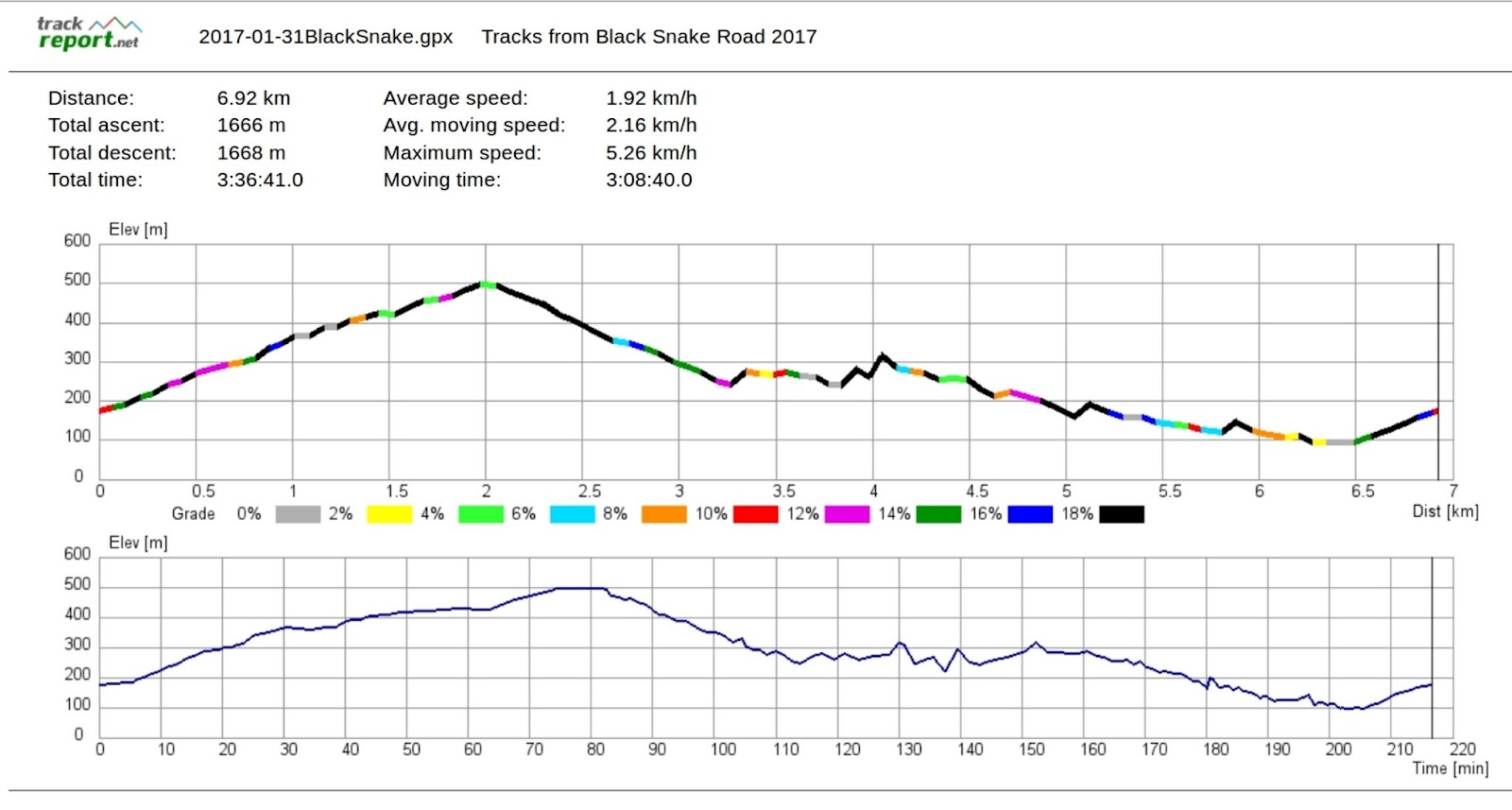
Being in a valley plays havoc with the GPS, so take the figures with a grain of salt.
We had 14 walkers and covered just over 6km in about 3.5 hours. Remember your rule: every 100 metres climbed adds an extra kilometre. This means you can add about 10.3km to our 6km.
As it was the same walk as before, I've used the previous map and Google Earth view.
Anyone who desires the GPS track, can get it from the 2015 blog.


No comments:
Post a Comment