Today Bob is leading us on a new walk at Sorell. A bit different from our usual walks due to the lack of hills, never the less it looks very interesting.
Parking in the Pioneers Park just above the Sorell Rivulet, we gather around Bob while he relates some of the history of the area.
Briefly, originally named Pittwater, Sorell was renamed in 1821 after Van Dieman's Land Lieutenant Governor William Sorell. He had hopes that Sorell would become the capital of Tasmania.
 |
| History class |
Lesson over, we head towards the rivulet and the substantial track running along it.
 |
| Leaving the car park |
 |
| The Sorell Rivulet is just below us |
 |
| Started in 1890 and closed in 1926 |
Judging from the amount of housing being built and the amount of car traffic, perhaps the railway needs a rethink to get around the traffic congestion that occurs almost every morning.
 |
| Sorell Rivulet |
On we go, coming to our first colonial farm. Kidbrook by name.
 |
| Kidbrook |
 |
| Sorell 1896 |
|
On we go, slowly heading for the causeway.
 |
| Heading towards and around the industrial area |
 |
| The rivulet looks prettier here |
Shortly, we reach Main Road, turning left for the short walk to the causeway.
 |
| Midway Point in the distance |
The weather isn't too bad for walking, a bit windy but not uncomfortable.
Reaching Midway Point, we settle beside the road for Morning Tea.
 |
| Morning Tea |
There were several large rocks scattered around here and I found a nice comfortable one all to myself next to the dog poo bin.
Break finished, Bob heads us towards the depths of Midway Point.
 |
| Pontos Hills in the distance |
 |
| A glimpse of the causeway |
 |
| A bit of colour bordering Orielton Lagoon |
 |
| Looking towards Sorell |
 |
| Rain in the distance |
We had none of the bad, wet weather until we were on our way back to Kingston.
Lagging behind taking photos, I heard a ruckus ahead of me.
 |
| The cause of the ruckus |
Hastily turning uphill away from the loose guard dog, we head for the street.
 |
| Caution is the better part of valour |
We head right at the top and I am surprised at the amount of new building going on.
 |
| New homes behind Midway Point |
Infrastructure such as transport never seem to be considered before we build new housing projects. Only when it becomes apparent that the people living here are having problems getting anywhere, does it come up.
The photos don't do justice to the number of new houses.
 |
| At least you get a good view of Mt. Wellington |
We leave the development behind, taking a rough path that runs along Penna Road. It's not long before we come across two blokes building a proper walking/cycling track which is an extension of the one you see in the photo below.
 |
| New track along Penna Road |
We cross over here to head down to the foreshore of Pitt Water and head for Penna Beach.
It has some interesting geology along the way.
 |
| Looks like a project in progress on the water |
 |
| Hope they get it finished for summer |
 |
| The tide is in |
 |
| The geology I mentioned |
The land changes suddenly from above to the sandstone below
 |
| Mini sandstone caves |
 |
| Penna Beach just ahead |
We leave the water behind and follow a track that takes us to Shark Point Road and our lunch spot.
 |
| Heading towards Shark Point Road |
 |
| The lunch spot (for some)... |
 |
| The rest settle across the road. On the ground |
After lunch, we continue along the track that heads back towards Sorell. The photos give you some idea how flat the land is around here.
 |
| I'm really impressed by the length and number of paths around Sorell |
 |
| Somewhere in the far distance is the causeway we crossed earlier |
I was hoping you could make out tiny cars in the distance, you could just see them with the naked eye.
After a while, we turn off towards Sorell.
After a while, we come to the old Anglican Cemetery which would be interesting to explore if one had more time.
We head past with only a short stop.
 |
| We pass a large field covered with for sale signs for blocks of land |
Soon we enter the outskirts of Sorell and Bob makes me take the photo below and say that he didn't take us on the circle mentioned on the sign.
Just to show you what we missed, I've provided a Google Earth photo below.
 |
| The circle Bob didn't take us on |
It's all retirement homes, I believe. In fact there are a large number of retirement homes in Sorell, or so it appears.
We head along Henry Street, turning left onto Arthur Street and reaching our first sandstone building.
 |
| This is now the Uniting Church and is surrounded by houses |
 |
| Not so back in 1896 |
Across the street is the Catholic Church.
There are some lovely old buildings in Sorell and are well worth a look.
 |
| The old Blue Bell Inn |
This is a private B&B now, but was originally a wooden building built in 1829 that burnt down in 1863. Then the existing sandstone building was constructed. Licensed until 1907, it variously was used as a drill hall in WWI, an influenza hospital and was run as a maternity hospital from 1936 to 1945.
It's only a short walk back to the cars and the end of the walk.
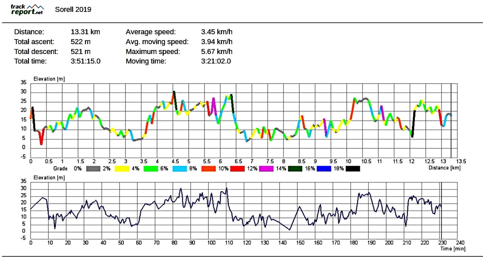
We had 11 walkers and covered 13.31kms in 3:51hrs. A very interesting walk taking most of us to parts of Sorell and Midway Point we didn't know existed. Thanks to Bob for putting it together for us.
Click here to download GPX file


No comments:
Post a Comment