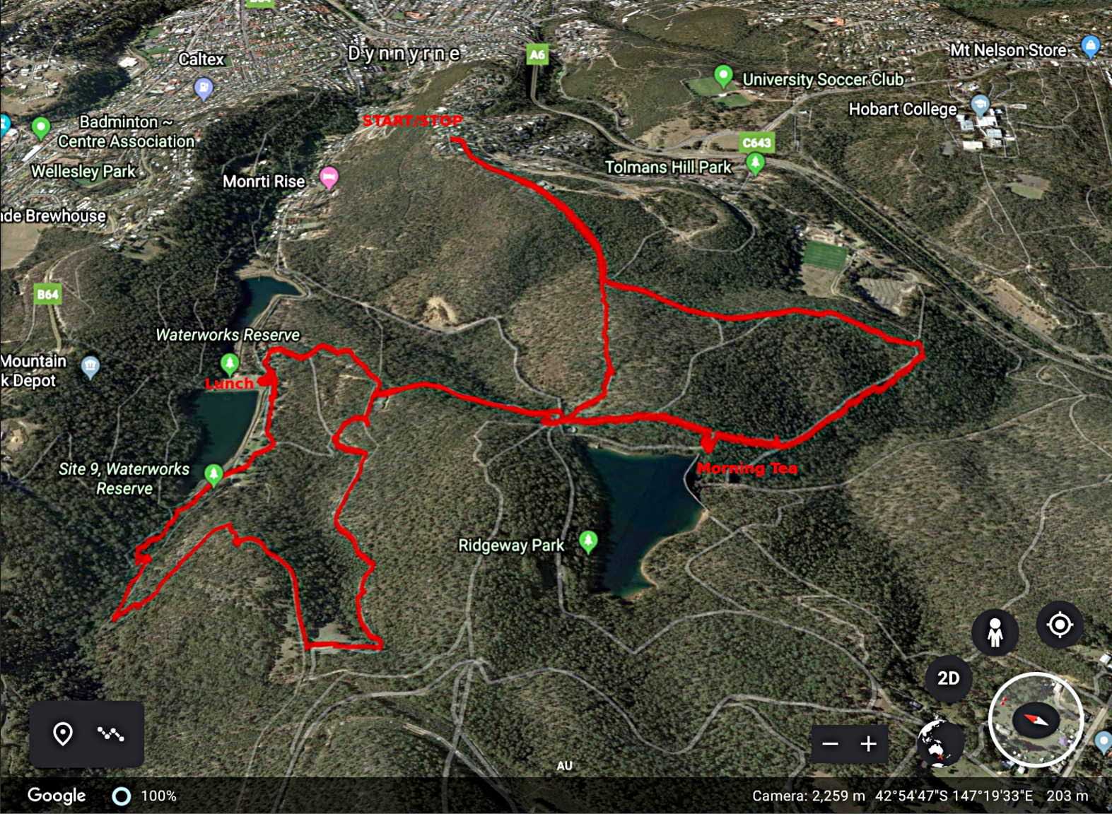
Today we're walking from the top of Tolmans Hill down to the Ridgeway reservoirs and back.
We've done this walk before so this time I thought we'd do it in reverse. I have the track from before on my GPS, what could possibly go wrong?
It's an overcast day with the possibility of showers later as we set off from Woodridge St. up the access to the top of the hill.
 |
| Up the access from Woodridge St. |
 |
| The first part of the walk is fairly flat |
Soon, however we start down hill. There will be a lot of downhill today, which means a corresponding number of uphill treks.
 |
| Down we go. I reminded them we'll be climbing up here later |
 |
This area has had many varied activities
over the years and old tracks are everywhere |
At the bottom of that first descent, we turn left onto another track and I begin to keep an eye open for the spot where we turn off to the right.
The GPS shows me the spot, but it's pretty clear anyway as we'll be following an old pipeline. This will eventually take us to the Ridgeway Reservoir, sometimes called the upper reservoir.
Ron and I are at the front when we spot something ahead. From the shape, we conclude it's an industrial bush toilet.
 |
| Bush toilet |
Our guess about it being a toilet is confirmed in the next photo. Obviously of American origin as a "John" is equivalent to an Aussie dunny or loo......
On we go following the pipe up hill and down dale until we reach the dam.
 |
| Looking ahead |
We reach the dam just in time for Morning Tea.
 |
| Morning Tea |
Break finished, we walk the short distance back to the track and head for the other end of the reservoir and Ridgeway Road.
As we reach the junction I look at my GPS to find where we will start down on the other side. Nothing. Blank screen. The spare, fully charged batteries are dead. I change the batteries and reboot, but it takes a while. I resort to old fashioned paper and choose a track leading down.
 |
| Water level's low for this time of year |
 |
| Heading down |
As we wait for everyone to catch up, I spot a local across the road.
 |
| From this angle, our local seems to have a very fat tail |
On we go, finally reaching the Water Works and the upper and lower reservoirs. After facilities have been used, we have a discussion re lunch.
We can see Mt. Wellington from here and it appears showers are heading our way.
 |
| Mt. Wellington with showers moving in from the left side |
I suggest an early lunch as there is a shelter nearby, so we move in and settle down. Rain soon arrives with a couple of drops then becomes heavier.
We're OK inside but it seems apparent we're going to need our wet weather gear when we leave.
 |
| Lunch |
 |
| Wet weather gear comes out |
It seems we have a wanna be council worker with us. I get out my jacket, which is rare, and we brace ourselves for a wet walk.
Out we go, heading for the top of the upper reservoir under the guidance of Ron & Wayne. Are we getting wet? Well no, because as soon as we left the shelter the rain stopped and the sun came out. How's that for planning?
It does mean another stop to strip off again!
On we go, I'd forgotten about this track which will take us to Gentle Annie Falls.
 |
| Sun's out and everything's alright with the world |
 |
| We cross the Sandy Bay Rivulet |
 |
| Rocky outcrop farther up the hill |
 |
| The track widens and becomes flatter |
 |
| Soon we reach the climb up Gentle Annie Falls |
You may notice that it stops being flat here.
 |
| The reservoir we left behind |
 |
| The top |
Gentle Annie isn't a waterfall at all. Convicts cut a channel into the sandstone to deliver water from farther up to the reservoirs. It wasn't until 1940 that the water was redirected around the falls by pipeline.
The photo below is from about 1906 and shows what it used to look like.
We walk up the Pipeline Track, turning off at the McDermotts farm track.
I didn't realize that McDermott's farm existed up until the 1967 bushfires. Bill McDermott, 80y.o. at the time, saved his home, dog Brandy and some of his cattle but was killed by one of his bulls a few days later. The Hobart City Council subsequently destroyed his home.
 |
| View from about the location of the farmhouse |
 |
| Hobart and Eastern Shore below |
 |
| "Oh look! Another hill!" |
As we're leaving the farm I get a shout from ahead to come along and get my camera out. I thought they were looking at a bird until I realized it was something else on the ground.
 |
| What all the fuss was about. A Mountain Dragon or Rankinia diemensis |
Not too far along something else is taking some of the group's interest.
 |
| Commonly known as poo |
I took the photo and hoped to identify it when I got home. It's too large to be a rabbit and too small to be wombat.
I had a look for something similar in my
PooFlip - Life-size guide to the scats of Tasmanian native mammals,( and yes, there is such a thing,) but could find nothing.
Perhaps it's a young wombat who isn't squared away yet.
Note: Wombats do cube shaped poos for those who don't know.
On we go, and by this time I have my GPS working again. We're heading for the track we came down earlier from Ridgeway Road. It seems from the display we're heading down and Wayne & Ron realize it the same time I do. Nothing for it but to go off track for a little climb.
 |
| Going up |
We find the track we want and make our way back to Ridgeway Road, turning left and uphill for our return journey to the cars.
 |
| It's a climb but not too bad |
 |
| You can look out over rolling hills and not know a capital city is a few minutes away |
Leveling off at the top the track takes us back to the cars.
 |
| Safely back |
We had 15 walkers and covered 10 km in 4:51hrs. We climbed 1191metres.
Click here to download GPX file


No comments:
Post a Comment