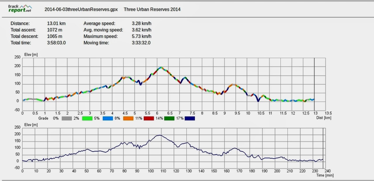
Todays walk took place in misty rain & fog, with low cloud on the hills. Sally led us on a between terms walk, that took us around some of the reserves around the areas of Lenah Valley, Mt. Stuart, North Hobart, the Domain and Botanical Gardens and back to the cars via a riverside path.
We parked at Cornelian Bay, put on our rain gear and walked across the first athletic oval to a colourful tunnel leading under the Brooker Ave.
This took us down to a path running parallel to the Brooker, before we turned off on Risdon Rd. A short walk brought a turn off on a small reserve and eventually to Tower Rd.
 |
| Crossing Risdon Rd. Near an original Colonial building. |
 |
| Associated sandstone house on Risdon Rd. |
 |
| Following path that runs behind New Town High School. |
 |
| New Town Rivulet |
We picked up a walk that led along the New Town Rivulet behind the New Town High School. This is a made track that includes raised wooden sections under the railway line, and reaches Creek Road by crossing New Town Road.
It wasn't really cold, but we did have a misting rain constantly. We walked up Creek Rd., passing the Transend Substation, until we turned off for Morning Tea at John Turnbull Park. (My uncle and cousin in the States were, and are John Turnbull).
 |
| Walking up Creek Rd. |
 |
| Morning Tea with the traditional separation of male and female. |
Leaving the park, we crossed the road and started a section that was new to just about all of us. The crossing over Augusta Rd. took us into the car park of the Lenah Valley RSL club, where we found the entrance to Haldane Reserve. A new one on me. Sally pointed out an overgrown track to the right of where we were going, and told us that a small section of the original Hobart to Launceston road was in there.
 |
| Haldane Reserve |
 |
| Possibly a Nerine |
Walking up, I heard Sally comment that we were going to walk "Up and around, then up and up". I felt it only right to make sure everyone behind me was made aware of that. I think they appreciated that, judging from the moans.
This track passes along the rear of older properties, with Pottery Creek at the bottom. We finally came out at Pottery Rd. and cross over into Doyle Ave.
 |
| I think these are the remains of an old orchard. |
 |
| Looking across Pottery Creek, looks like civilization is getting near. |
Turning right, we walk up Giblin St., cross through houses on a short track to Keith White Crescent. A stiff walk and a little moaning brings us to the Roundabout at Mt. Stuart. Continuing on, we turn just past the Mt. Stuart Primary School onto Clift St. Walking at this point is making just about everyone happy as it's downhill.
 |
| Needs good cleanup |
 |
| Architect designed homes (or chook houses) on Mt. Stuart. |
Sally had originally planned to take us up onto Knocklofty via various (uphill) tracks, but as I said earlier, views would have been nonexistent, so we lost about 4km of hills. Oh dear.
We turned off Clift st. into another small park I've never heard of before, called Providence Valley Reserve. It led down through a gully lined with gums and bordered on both sides by houses. Bob spotted some fungi which he pointed out to me.
 |
| Providence Valley Reserve |
 |
| To be identified |
 |
| Ditto |
Exiting onto Cato Ave, we followed it around to Valley St. via Rupara Ave. We found the path through the Leonard Wall Valley St. Reserve, we crossed over Mellifont St. into Lower Jordan Hill Rd. My late father-in-law, used the steep hill on Mellifont to test cars he had repaired.
 |
| Clouds start to clear, but it didn't last. |
Walking down Jordan Hill we passed many older, attractive houses before turning left onto a short path to Swan St. We're now in the realms of North Hobart.
We did spot a rare example of fauna in someone's front yard.
 |
| Long hair, flop eared roo |
There are some nice old buildings on Swan St., one of which attracted Bob's attention.
 |
| Swan St. |
 |
| Bob felt strangely attracted by this building. |
Having seen several large men in white coats carrying large nets, Addie and I convinced Bob he'd better move on. Quickly.
A short walk down comes to Elizabeth St. and a left and right to Federal St.. where we continued down to the Old State High School, left at the Brooker and up and over on the pedestrian bridge to the Hobart Domain.
 |
| Brooker Ave looking north |
 |
| Track from pedestrian bridge up to Domain |
I found an old photo of the High School which is below. I was mainly interested to see how the Domain has changed, I think you can see the zig-zag path we went up.
 |
| Old Hobart State High School with Domain behind. |
We reached the top and crossed over a couple of the ovals at Five Ways corner, continuing down, crossing over the Upper Domain Rd. twice. Picking up a new track next to the observation shelter, we walked down to Lower Domain Rd. turning left to walk down to the lower entrance to the Botanical Gardens. This took us in to the convenient shelter with seating for lunch.
After lunch we crossed the gardens and out over the Domain Highway, to pick up the Bike/Walking track next to the rail lines. We walked up this before turning off on a gravel track along the shore of the Derwent River. Not a bad walk, it would have been even nicer in sunny weather.
 |
| Still foggy |
 |
| Shoreline path |
Anyway, we came to a turnoff on the Boatsheds Track which carries us along the shore of Cornelian Bay, behind the boathouses. These have been here for years, and are very popular and expensive. Most of them have been done up with some mod cons added.
 |
| Boathouses |
 |
| Maybe this should be the art shot. |
We're near the end as the cars are in sight. While walking back, I spotted a new form of fungi, which I haven't been able to find in any reference book, nor on the Internet. I'm claiming these as unnamed, so I have decided to apply my own.
They're unique in their size, uniformity, lifespan and the fact that they seem to grow in a fairy rectangle rather than a fairy circle.
 |
| Anklebiterus playgroundii |
We had 9 walkers and covered 13km in 3:58
Click to download GPX file